
HOW CAN I TELL IF POOR ROVER SYMPTOMS ARE DUE TO SPACE WEATHER ISSUES?
Your issues may be due to other factors, but you can see the current space weather status to help troubleshoot. Like many RTNs, our network tracks the effects of ionospheric activity with data from our own sensors. To see the status (for the current day or past days), log into either of our websites and choose the ‘I95 Ionosphere option in the upper left’. The I95 is a common index (Wanninger) that has been adapted for the I95 index on our network. The value is calculated for each subnet; it is one value. The higher it is, the more likely a rover will be impacted by ionospheric disturbances.
The rule of thumb for interpreting the I95 (as adapted for our network) is:
- Below 2 (below green): Very low activity, no impact
- Between 2 and 4 (between green and yellow): Normal activity, very little impact
- Between 4 and 8 (between yellow and red): Increased Impact can be noticeable (e.g., longer initialization times for the rover)
- Above 8 (above red): High Impact very likely noticeable (e.g., potentially no rover fixes at all)
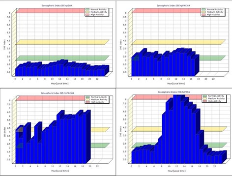
Examples of I95 plots from different subnets on different days. Clockwise from upper left: Below 2 (very low activity), Between 2-4 (normal activity), Between 4-8 (increased activity (noticeable effects), Some periods above 8 (possibly no fixes).
IRIM/GRIM graphs
Another set of plots can help estimate what the positional errors might be due to space weather conditions. Values show the "predicted remaining error" and indicate the estimated impact you could expect in a rover measurement. This is the error that remains that cannot be completely modeled out. IRIM/GRIM can be calculated for the whole network or for individual stations. The network value is the average of the individual stations in a subnet. The method works in a way that, e.g., network software takes the whole subnet, takes out one station, and sees how the Iono model fits to the actual observations on that station. The part that does not fit is represented by IRIM. GRIM shows the remaining error with respect to the coordinate. In the example below, during a heightened space weather period, you may have 18mm of IRIM error (left), and 9mm of GRIM error (right) remaining. Of course, the conditions for where you are may vary, but these plots can be a good indicator of expected results.
Typically, you will do better than the plots indicate, as they are looking at a whole subnet.
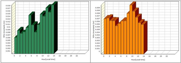
Examples are the IRIM plot (left) and GRIM plot (right).
Note that if you can fix (even under high conditions), you are probably OK, but keep an eye on your residuals. Only when it goes into the red for several hours would you see enough degradation to consider using non-GNSS methods. In our 20+ years of operations, we have only experienced a handful of days when GNSS field operations were not recommended, but often only for a part of those days. If you have a handheld recreational GPS unit and it is having trouble getting a position, that can confirm that the current conditions will not be good for your rover.
No questions yet.