
In New Orleans, During Its Tricentennial
September 12-15, 2018
The Surveyors Historical Society is dedicated to exploring, preserving and teaching the accomplishments of surveyors. Their annual Rendezvous has grown to become a premier event in the United States, educational, affordable and fun and anyone may attend! The Louisiana Society of professional Surveyors is hosting the event with Ralph Gipson’s leadership as chairman.
The Surveyors Historical Society erects a monument or researches some important survey corner as part of each year’s Rendezvous. The New Orleans Rendezvous in the fall of 2018, will see the preservation of the first Initial Point in the Public Land Survey System. The Government Land Office surveys started in the Mississippi
Territory in 1803 with a 40-mile experimental line run from Natchez Mississippi to the 31st Parallel set by Andrew Ellicott known as the “Line of Demarcation”, or “Ellicott’s Line”.
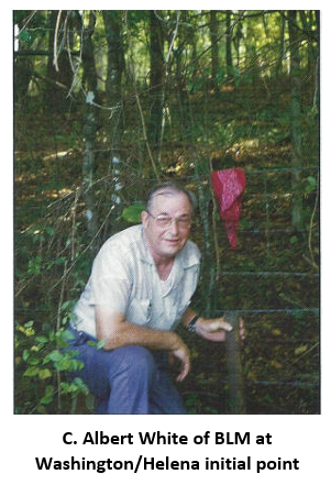
Deputy Surveyor Charles Defrance ran East 6 miles and 12 perches Commencing at a mound (# 18) set by Ellicott, where on November 27th, 2018 he set the Initial Point of the Washington Meridian. Thomas Freeman returned to this Initial Point in 1819 and ran a Meridian South that became the St. Helena’s Meridian, which controlled GLO surveys in Louisiana.
An iron pipe as shown in Albert White’s book on Initial Points of the United States currently marks the point (30-59-56.0 N, 91-09-36.8 W). The line of demarcation has been researched by Milton Denny, PLS and Larry Crowley PE, PhD. Additional work needed to prove the correct location including looking for original witness tree ties will be performed in the field research in May.
Once the correct location is proven, the plan is to have a stone monument cut about 4 feet in height and 12 inches square with Washington Meridian inscribed on the North side, the South side will say St. Helena Meridian, the East side will say Line of Demarcation and the West will say Ellicott Line.
The LSU Center for GeoInformatics (C4G) supports efforts to preserve survey controls and their histories. Mr. J. Anthony Cavell, resident surveyor for the LSU C4G will join in the proving survey May 11 & 12. Mr. Cavell, is also one of the featured speakers at the Rendezvous in September. Watch this space for updates.
Click here to visit the Surveyors’ Historical Society website. Click here to download the event brochure.
The NGS has issued a notice on their website regarding observed discrepancies between the 2009 and 2012 GEOID models. The notice expansion on August 8, 2012, came in the wake of analysis performed by the LSU Center 4 GeoInformatics back in the week of July 15th where we identified issues in Louisiana, Mississippi, Texas, and other states within the CONUS. C4G notified the NGS of the issues found during the ESRI conference in San Diego, CA during the week of July 25th and we are working with them to resolve the problems as soon as possible.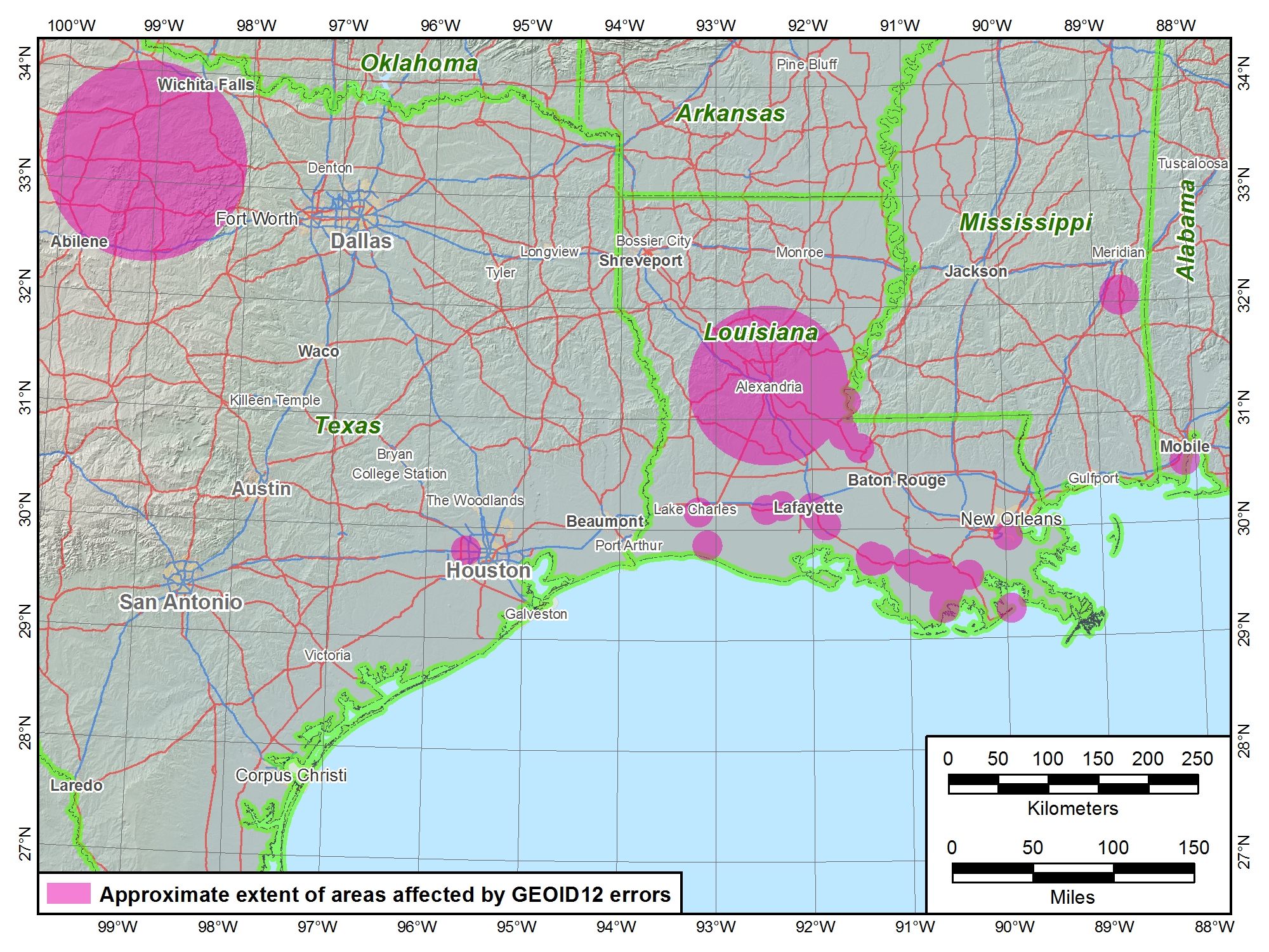
You may find it useful to do your own testing of GEOID12 in your project area but C4G is recommending that everyone in Louisiana stick with GEOID09 until we learn more about what caused the issues we are seeing in GEOID12 and have confidence that NGS has resolved or justified the differences we are seeing to our satisfaction.
You can keep up with this and other C4G related topics by following us on Twitter, Facebook, YouTube, C4Gnet RSS feed and the C4G website. The following is a copy of the NGS Notice Update.
**NOTICE UPDATE**
GEOID12 errors found in northern Gulf Coast region
The National Geodetic Survey (NGS) has determined that the new hybrid geoid model, GEOID12, contains localized errors in Louisiana, Mississippi, Texas, and Alabama. Some of these errors are in addition to those identified in the previous notice. Click here for more information.
Vertical controls for all surveys shall be determined in the North American Vertical Datum of 1988 (NAVD88). All measurements shall be referenced to local control stations of the National Spatial Reference System, specifically the public domain Louisiana State University Continuously Operating Reference Stations network or other currently National Oceanographic and Atmospheric Administration National Geodetic Survey approved reference stations, such as benchmarks, monuments, or continually operating reference stations.
The National Geodetic Survey (NGS) issued a notice on Saturday, August 4, 2012 stating that they have determined that the new hybrid geoid model, GEOID12, contains localized errors in Louisiana and Mississippi. Click here for more information.