C4GNet RTN Automatic Rover Fail Over System!

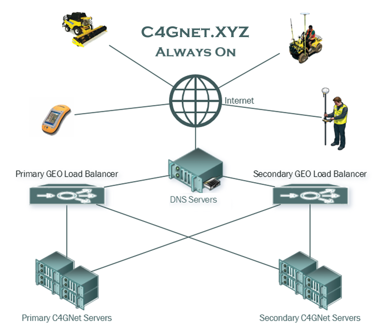
In an effort to deliver the most robust Real Time Network end user experience, C4G has implemented a redundant system of Global Load Balancers that automatically switch RTN users over to the equipment providing the best quality of service. C4G has maintained primary and backup servers for years but end users have always had to switch the hostname manually in their rover settings. With the new Always On redundant global load balancing system a rover simply needs to set the RTN hostname to C4GNET.XYZ and the DNS servers will direct the connection to the primary or secondary global load balancer based on weighting and availability. The global load balancers continuously monitor the quality of service at the NTRIP servers and pass the rover off to the primary or secondary NTRIP server based on quality of service and availability. The RTN Always On system is currently online and C4G encourages all clients that want to take advantage of this new improved fail-over feature to switch their host address C4GNET.XYZ to take advantage of the robustness of C4GNet's Always On RTN
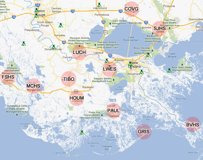
C4Gnet remained online during Hurricane Isaac but eleven CORS sites went offline for the most part due to power outages in the wake of the storm. C4G will be working to get all of these sites back online as soon as possible. While network solutions are still possible in Southeast Louisiana, extra care should be taken do checks on important points until the network density is restored in this area.

LSU Center for GeoInformatics invites qualified professionals* to subscribe to the C4G Real-Time Network! C4G RTN is a network of Continually Operating GPS Reference Stations (CORS) that delivers Real Time Network error corrections for GPS data providing the next step of sophistication serving the aims of research in surveying, geology, subsidence, hurricane safety engineering and much more. C4G RTN provides real-time data for use by surveyors, construction crews, precision farming and others with appropriate equipment and training to further enable uniform ties to the National Spatial Reference System (NSRS) in Louisiana.
LSU C4G Real-Time Network (RTN) presently consists of over one hundred CORS distributed throughout the state that allow RTN subscribers to login and start working anywhere in the state of Louisiana. C4G RTN subscribers can also subscribe to a post processing service that has access to 1 second RINEX data from any or the CORS in the network and the ability to create Virtual Reference Stations anywhere in the state and generate RINEX files on the fly for these locations. C4G RTN has deployed the infrastructure to support the GLONASS satellite system and members can currently access GLONASS subnets anywhere in the state of Louisiana.
CLICK HERE to find the membership option that meets your needs at the C4G Web Store and start using the C4G RTN TODAY!
*Please note:
All subscribers will receive the same benefits and must agree to our TERMS OF SERVICE. Academic users must pursue research collaborative agreements with LSU C4G or a memo of understanding from the LSU College of Engineering.
The use of single and dual frequency satellite radio navigation systems, like the Global Positioning System (GPS), has grown dramatically in the last decade. GPS receivers are now in nearly every cell phone and in many automobiles, trucks, and any equipment that moves and needs precision location measurements. High precision dual frequency GPS systems are used for farming, construction, exploration, surveying, snow removal and many other applications critical to a functional society. Other satellite navigation systems in orbit include the European Galileo system and the Russian GLONASS system.
There are several ways in which space weather impacts GPS function. GPS radio signals travel from the satellite to the receiver on the ground, passing through the Earth’s ionosphere. The charged plasma of the ionosphere bends the path of the GPS radio signal similar to the way a lens bends the path of light. In the absence of space weather, GPS systems compensate for the “average” or “quiet” ionosphere, using a model to calculate its effect on the accuracy of the positioning information. But when the ionosphere is disturbed by a space weather event, the models are no longer accurate and the receivers are unable to calculate an accurate position based on the satellites overhead.
In calm conditions, single frequency GPS systems can provide position information with an accuracy of a meter or less. During a severe space weather storm, these errors can increase to tens of meters or more. Dual frequency GPS systems can provide position information accurate to a few centimeters. In this case the two different GPS signals are used to better characterize the ionosphere and remove its impact on the position calculation. But when the ionosphere becomes highly disturbed, the GPS receiver cannot lock on the satellite signal and position information becomes inaccurate.
Geomagnetic storms create large disturbances in the ionosphere. The currents and energy introduced by a geomagnetic storm enhance the ionosphere and increase the total height-integrated number of ionospheric electrons, or the Total Electron Count (TEC). GPS systems cannot correctly model this dynamic enhancement and errors are introduced into the position calculations. This usually occurs at high latitudes, though major storms can produce large TEC enhancements at mid-latitudes as well.
Near the Earth’s magnetic equator there are current systems and electric fields that create instabilities in the ionosphere. The instabilities are most severe just after sunset. These smaller scale (tens of kilometers) instabilities, or bubbles, cause GPS signals to “scintillate”, much like waves on the surface of a body of water will disrupt and scatter the path of light as it passes through them. Near the equator, dual frequency GPS systems often lose their lock due to “ionospheric scintallation”. Ionospheric scintallations are not associated with any sort of space weather storm, but are simply part of the natural day-night cycle of the equatorial ionosphere.
Phenomena:
Geomagnetic Storms
Ionospheric Scintillation
Total Electron Content
*All of the information on this page is from the Space Weather Prediction Center, which is a division of the National Weather Service & National Oceanic and Atmospheric Administration.
C4G launched C4Gnet.XYZ in January 2018 and this launch had so many important advancements bundled into it that there is too much to give all the details in the RTN User Guide. In this article we will try to give you some insight on the tools and features that are all rolled up into the C4Gnet.XYZ RTN launch.
First a little background information on the very important change to C4Gnet.XYZ.

C4G originally made the switch to using RTN as our host address years ago to provide a robust failover method that allows RTN users to be directed to any of our servers without having to make any changes in their rover settings. We have a network of high availability firewalls, load balancers and database servers that are monitored for quality of services and weighting and direct clients accordingly to the best services dynamically. This made the C4Gnet RTN very reliable and is only possible when clients use DNS for the host address. This DNS or Domain Name System was based on the top level DNS of LSU.EDU and worked perfect for years until LSU made a change to tools that manage DNS for the LSU.EDU top level domain. This change required the DNS to be pointed to a single IP address removing the ability for C4G to redirect the DNS dynamically! The only way to fix this was to get a new DNS that was not connected to the top level DNS, LSU.EDU, so C4G acquired the domain C4Gnet.XYZ in an effort to restore our robust dynamic failover capability.
- C4Gnet.XYZ restores our High Availability Always On robust failover ability and we encourage all clients that can use DNS Host Addresses in their rover setups to do so!
With this launch the LSU Center for GeoInformatics introduces a new version of the Trimble Pivot Platform software package.
New features deployed in this software release include the following:
- C4Gnet GNSS Online Post Processing
- VRS iScope
- iScope Live!
- Real Time RTXnet Processor using Precise Point Positioning (PPP)
- New mountpoint naming convention
- New PPP and NSB Mountpoints
- Multi-Reference Frame Support
- GNSS Galileo and BeiDou Support
RTX Technology
The RTX Technology infrastructure is a unified framework for estimating satellite parameters for any GNSS satellite. GNSS field receivers use advanced Precise Point Positioning (PPP) processing algorithms to combine RTX corrections with local measurements and produce cm level accurate absolute positions.
RTXNet Processor
RTX Technology enables the RTXNet Processor to develop corrections for a full range of satellite systems and delivers Network-RTK corrections for GPS, GLONASS, BeiDou, Galileo, and QZSS. Using a PPP mountpoint gives rovers a second real-time method to collect data and as a real-time way to check data collected with a real-time VRS RTK mountpoint. If data collected with both PPP and RTK agree, you have a very high confidence that the data collected is accurate.
