POSITION REPORT
GNSS Market Research and Analysis GPS/GNSS Networks and Services The Global Market for GNSS Augmentation Infrastructure and Services 2009-2013 March 2009 Abstract ©Position One Consulting Pty Ltd 2009 All rights reserved Authors Robert Lorimer & Eric Gakstatter
Global Navigation Satellite Systems (GNSS) include the United States GPS (the most commonly used today), Russia's Glonass, the EU's Galileo, China's Compass, the Indian Regional Navigation Satellite System (IRNSS) and Japan's Quasi-Zenith Satellite System (QZSS).
The signals from all these GNSS are subject to a myriad of errors and may not always tell the truth. Whereas this is not a problem for casual users or those who can tolerate such errors, there are many applications where integrity and accuracy must be improved.
Note that the LSU Center for GeoInformatics is actively pursuing the funding necessary to do the control work needed to create better GEOID models in Louisiana. Feeding well distributed vertical control data into future GEOID models will improve the vertical accuracy of these models and is perhaps our only hope of ever creating a ±1cm GEOID in the state of Louisiana. |
||
|---|---|---|
|
The NGS presentation on Friday March 15, 2013, pointed out that GEOID12a produces 95% confidence at ± 4 to 8 cm in Louisiana. The NGS conclusion states that the problem is too large for NGS to handle alone and we all need to work together to get better height results. They also recommend partnering with locals to leverage existing resources and that a plan needed to be created to move forward with improving heights. |
|
|
|
The presentation was given by NGS geodesists / scientists, Michael Dennis and Dan Roman.
|
||
|
Big picture ideas to consider from the presentation
|
||
|
Recently, NOAA’s National Geodetic Survey released updated orthometric heights for Southern Louisiana relative to the September 2010 GNSS Height Modernization project. These heights represent the most up to date heights available for the region. On March 15, 2013, NGS hosted a free, on-line webinar to present the results of this project. |
|
Visit the NGS page for this event To download the .mp4 file, click here. Link to the presentation: |
C4G CORS used in C4Gnet and GULFNet Real Time Networks have been valued at over 33 Million dollars a year according to a new government report released June 15th, 2009. The report titled "Socio-Economic Benefits Study: Scoping the Value of CORS and GRAV-D" was prepared for the National Geodetic Survey by Irving Leveson. It shows billions in estimated benefits from NOAA Positioning Products and Services:
• National Spatial Reference System (NSRS): $2.4 billion per year
• CORS: $758 million per year. (C4G has 27 of the 1324 National CORS)
• C4Gnet and GULFNet have 66 CORS with a yearly valuation of $500K each.
• GRAV-D (Once completed): $4.8 billion over 15 years, including $2.2 billion in avoidance costs from improved floodplain management.
Welcome to the LSU Center for GeoInformatics (C4G)
Home of the Louisiana Spatial Reference Center (LSRC) and the
GULFNet Continuously Operating Reference Station (CORS) Network

                  http://LSRC.lsu.edu
Access to all 15 & 30 second raw GULFNet CORS data in the repository are made
available freely to the public through the LSU C4G in its role of LSRC and
partnerships with members of the Gulf Coast Spatial Reference Consortium (GCSRC).
All GULFNet CORS log Observations each second and these observations are
perminently archived by C4G and made available only through a subscription
available at https://store.c4g.lsu.edu/.

FTP access is found at the following settings.
Host: cors.lsu.edu
FTP Port: 8021
Login Type: Anonymous
Note: raw CORS data is used in geodesy post-processing tools like Trimble Business Center, Leica Geo Office and Topcon Tools. GIS data collected autonomously can also be differentially corrected against raw CORS data in software tools like Trimble Pathfinder Office.
Contact your GNSS dealer if you need help setting up a connection to the C4G CORS FTP server or need details on the tools necessary to post-process GNSS data.
Access to all GULFNet CORS data in the repository are made available freely
to the public through the LSU C4G in its role of LSRC and partnerships with
members of the Gulf Coast Spatial Reference Consortium (GCSRC).
=================
Data can be retrieved using command line or FTP client via anonymous ftp
from CORS.lsu.edu on port: 8021 or with HTTP by pointing your browser to
http://cors.lsu.edu/ (due to increases in security efforts not all
browsers support direct access using the FTP protocol) so we have accommodated
browser access through HTTP instead of FTP.
GULFNet CORS stations are owned and operated by C4G or our partners in the
GCSRC - Gulf Coast Spatial Reference Consortium.
GULFNet CORS data are distributed to the public free of charge.
All LSRC CORS GNSS data files collected from GULFNet CORS stations are made
available to NGS & the public in Trimble’s proprietary data-file formats
(R00/T00/T01/T02) or (.DAT or .TGD). All GULFNet CORS files found in this
data archive are logged in formats native to Trimble GPS/GNSS receivers
from "Record Type 27" (RT27) files. The data include observation,
meteorological, navigation/ephemeris for the stations. Most data are
available within 1 hour from when they were recorded at remote CORS sites.

Louisiana NGS CORS
========================
NGS redistributes some of the GULFNet CORS data to the public free of
charge through its partnership with the LSRC at LSU's Center for
GeoInformatics. NGS publishes its subset of the GULFNet CORS data through
their CORS website found at the following links.

	https://geodesy.noaa.gov/corsdata/

NOAA's National Geodetic Survey (NGS) operates the Continuously Operating
Reference Station (CORS) network that consists of group of Global
Navigation Satellite System (GNSS) reference stations which provide code
range and carrier phase data to users in support of postprocessing
applications. The stations are owned and operated by federal, state, local
agencies, private companies, and university groups, and NGS redistributes
their data to the public free of charge.

The GNSS data collected at these stations are made available to the public
by NGS in Receiver INdependent EXchange (RINEX) format. The data include
observation, meteorological, navigation/ephemeris, station logs and NGS
coordinate files for the stations. Most data are available within 1 hour
from when they were recorded at the remote site, and a few sites have a
delay of 24 hours.

ACCESS TO DATA
=================
 Data can be retrieved via HTTPS with your browser from geodesy.noaa.gov

       https://geodesy.noaa.gov/corsdata/

Alternatively a customized data request service is available at:
       http://geodesy.noaa.gov/UFCORS

FILE RETENTION POLICY
======================

RINEX observation, meteorological, navigation and TEQC summary files:
Hourly files are only kept for 2 days. Daily files are kept permanently,
However after 30 days the 24hr (daily) RINEX observation files that are
gzipped ({ssss}{ddd}0.{yy}o.gz) are decimated to a 30 second sampling rate
equivalent to the {ssss}{ddd}0.{yy}d.Z site specific GPS navigation files
are only kept for sites that NGS submits to the IGS network Meteorological
files are available only for sites with independent meteorological sensors.

After six-months to one year the second copy of the RINEX observation
files that are gzipped is removed i.e. file name {ssss}{ddd}0.{yy}o.gz.

All orbit files are kept permanently
Coord files are updated as needed
Logs files are updated as needed
Plot files are updated daily


NGS CONTACT INFORMATION
==================================

If you have questions about this file or about CORS in general please check
  http://www.ngs.noaa.gov/CORS/
  http://alt.ngs.noaa.gov/CORS
or email ngs.cors @ noaa.gov
Benjamin Fernandez has built this tool optimized for Louisiana that you can use by simply putting in a place, address or zipcode to search for what Benchmarks are needed in any area your interested in.
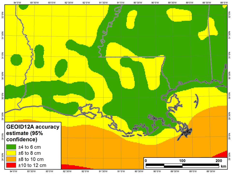 NGS plot shows GEOID12a produces 95% confidence at ± 4 to 8 cm in Louisiana