C4G is so much more than just fast/accurate GPS!
The LSU Center for GeoInformatics (C4G) was founded in 2001 by Dr. Roy K. Dokka. Dokka was a well-respected geologist, expert in faulting, who aimed to study the tectonic activity of the Mississippi River delta area, i.e., Louisiana and the Gulf Coast.
The usual tool for such studies would be precise geodetic leveling, [link] a tedious process heavily dependent on accurate benchmarks on which to base observations using accurate orthometric corrections. Recognizing the dynamic nature of our area with post-glacial subsidence and sedimentary compaction that rendered the traditional benchmarks unreliable, he devised a scheme to use precise Global Positioning System (GPS antennae mounted on geologically stable buildings as references for his geological studies.
The National Geodetic Survey (NGS) warmed to the idea of GPS reference stations (CORS) across Louisiana and supported his efforts through a seed grant that provided equipment for a few stations. Additionally, the Louisiana Spatial Reference Center (LSRC) was created at the C4G to make the archive data available to the public. This network was named GULFnet. [link]
The local surveying community recognized the potential of such a network, and they encouraged Dokka and C4G to make the GPS data available in real-time over radio or cell phone to enhance their performance and accuracy in the field as they worked. The Real-Time-Surveying (RTS) network (RTN) was born in 2007 and would become C4Gnet. [http://c4gnet.xyz/] Today, most who know of the LSU C4G, associate it with the C4Gnet, but there is so much more going on behind the scenes. The muscle behind the C4Gnet is a world-class, robust and redundant system of servers, communication, and backups managed by the administrator, Randy Osborne, and Vasiliy Dubinin with field maintenance by Larry Dunaway.
While the loss of Dr. Dokka in 2011 meant a reduction in the geologic emphasis, the geodetic functions of the LSRC continues. Dr. Ahmed Abdalla has been added to the line-up and brings his strong background into play. The dynamic geology of the Mississippi Delta (read: Louisiana) the accuracy of the geodetic data has always deteriorated quickly following surveys by NGS, C&GS, the Army Corps of Engineers, or others. The advent of using satellites for positioning opened the possibility of improved accuracy by which the CORS became the reference benchmarks for the traditional benchmarks. As the CORS antennae moved, their locations would be tracked and known immediately, and the traditional benchmarks could be referenced to them.
Having such fiducial references meant great strides might be made in observations of other forms of geodetic data.
- Ellipsoid heights of nearby benchmarks could be obtained from GPS observations.
- Application of good models of the Geoid could be applied to the ellipsoid values to calculate orthometric heights (elevations).
- Accurate positions and ellipsoid heights could be married with precise absolute gravity observations to develop more precise, accurate geoid models. (Defining the relationship between geometric and physical geodetic datums.
- Accurate positions and heights could be married with Absolute Gravity and Deflection of the Vertical (DoV) observations to enhance modeling of the geoid.
- Locating CORS close to a NOAA tide gauge enhances building the relationships between geodetic and tidal datums.
- Techniques used include Satellite positioning & timing, Trigonometric tacheometry, spirit leveling, absolute and relative gravimetric observations, and astro-geodetic deflection of the vertical observations.
In each case, the CORS serve as a nexus through which all the relationships are tied.
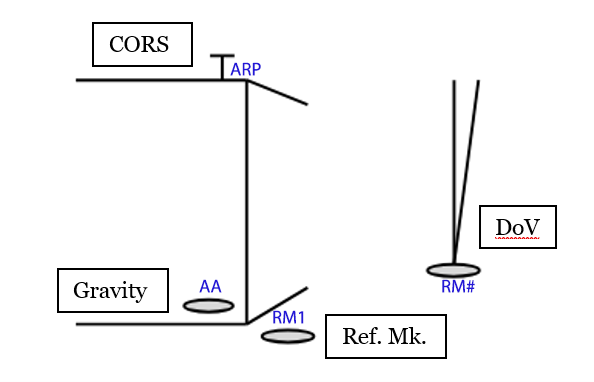
An attempt to show schematically how it works in practice is illustrated below.
- ARP -The GNSS antenna is the hub (ties are made to its reference point, the ARP)
- The CORS is usually accompanied by 3 or so reference marks (RMs) and absolute gravity marks (AAs) that are tied to the CORS and each other by tacheometry, plus an RM for DoV observation.
- RM1 - is set directly below the antenna, as near as practical.
- AA - is set indoors (climate controlled) as near as practical, beneath the antenna.
- RM# - The RM for DoV is frequently a little removed from the CORS to eliminate light pollution and on a soil surface rather than concrete to avoid high frequency noise. It is usually monumented with a magnetic monument set just below ground level. It is positioned with C4Gnet.
- RM2 & RM3 are positioned using the C4Gnet to enable orientation and redundant positions for RM1 and AA marks.

The LSRC participates in many of the efforts by NGS preparatory to the publication of the 2022 datums. An important one for Louisiana is the GPSonBM project. Many of the traditional benchmarks across the state were observed redundantly for use by NGS to develop the 2022 translation and adjustment. One potential project the LSRC is considering involves making gravity observations at the GPSonBM benchmarks to develop a slope-validation-network. This will be a labor-intensive effort, but we are optimistic. The geodetic field work is performed by Fernández PE, and Jon Cliburn and managed by J. Anthony Cavell.
For more information about how LSRC practice fits in with NGS’ recommendations follow this [link] (coming soon).
The Louisiana Spatial Reference Center was founded in 2002 as a partnership between NOAA’s National Geodetic Survey and the LSU Center for GeoInformatics to create state-of-the-art positional infrastructure for the state of Louisiana and to provide technical leadership, training and access to positional data. It operates GULFnet, a network of high precision Global Navigation Satellite System receivers used as reference stations throughout Louisiana.
J. Anthony Cavell PLS, CFedS is the resident surveyor for the LSRC/C4G and serves as the State Geodetic Coordinator.
