
Why C4G Has Taken On The Study of Gravity In Southern Louisiana
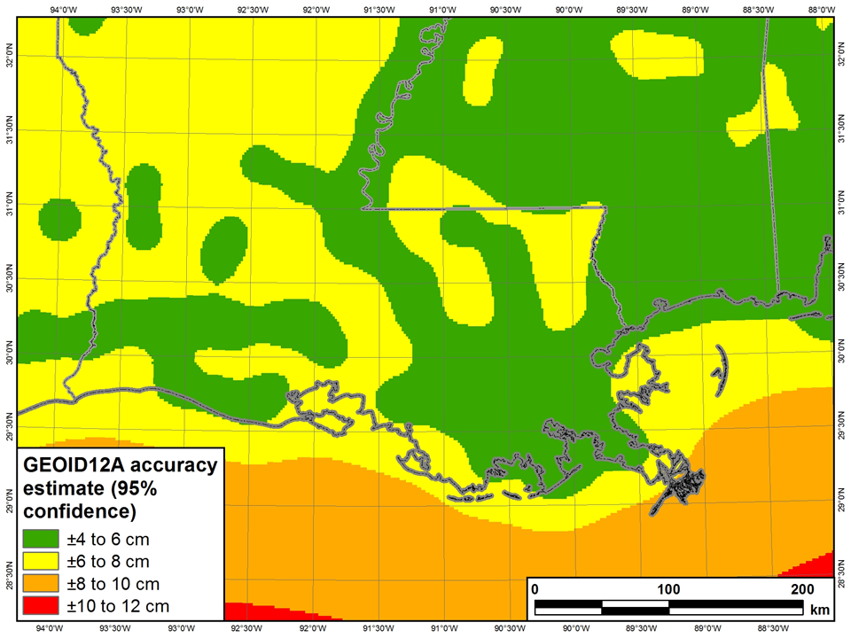
In March 2013, NGS made a presentation on its 2010 GNSS Height Modernization project in Southern Louisiana where they pointed out that GEOID12a produces 95% confidence at ± 4 to 8 cm in Louisiana. This is a problem since the goal of the NGS GRAV-D project is to establish a 2 cm GEOID for much of the country. The NGS conclusion states that the problem in Louisiana is too large for NGS to handle alone and that we all need to work together to get better height results. They also recommend partnering with locals (like the C4G LSRC) to leverage existing resources and that a plan needed to be created to move forward if we expect to improve heights in the 2022 vertical datum which will be based on a gravimetric geoid.
 Big picture ideas NGS presented to consider regarding the GEOID problem in Southern Louisiana
- Short term (through ~2015)
- Extend 2009 MS leveling into and across LA
- Establish GNSS infrastructure to monitor subsidence
- New ~2015 GNSS Height Mod survey (gives 10-year delta time)
- Medium term (~2016-2022)
- Terrestrial gravity surveys
- Incorporate GRAV-D aerial gravity into geoid model for region
- Long term (~2022)
- New vertical datum based on gravimetric geoid
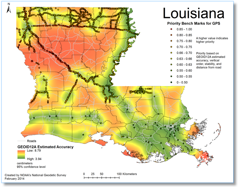
Because C4G already had the GNSS infrastructure in place and in its role as the Louisiana Spatial Reference Center (LSRC), C4G was already an active Height Mod partner, in 2013, the LSU Center for GeoInformatics started actively pursuing the funding necessary to do the terrestrial gravity surveys and control work needed to create better GEOID models in Louisiana. Only by feeding well-distributed vertical control data into future GEOID models will we be able to improve the accuracy of future GEOID models. And that is perhaps our only hope of ever creating a ±2cm GEOID in the state of Louisiana.
Through funding from Height Modernization and Board of Regent grants, we acquired two relative gravity meters. C4G then self-funded an absolute gravity meter with the intention of capturing the data needed to feed future GEOID models and help NGS reach their 2 cm GRAV-D goals in Louisiana.
The Gravity of our Positions!
Physical Geodesy is the science of the variations of the Earth's gravity field. The Geodesy of Subsidence has been an active topic of research in the LSU System since the middle 1980s. The intensity of the Earth's gravity at any spot on the surface is a function of the density of the Earth's crust at that spot and the distance to the center of mass. In a homogeneous sedimentary basin (Lower Mississippi Valley and the Delta), the density is practically constant except for occasional salt domes; therefore any variation in the gravity field may be attributed directly to changes in elevation, which usually relates to subsidence in Louisiana. Some "noise" can result from significant changes in groundwater.
Relative gravity surveys have determined the magnitudes of change from one elevation benchmark to another in the Gulf Coast Region, including Louisiana but the initial starting point has necessarily had to be assumed until the advent of Absolute Gravity observations made in the early 1990s. Re-observation of Absolute Gravity in New Orleans has been performed six times since then, and each new observation has shown a constant subsidence rate of 9.1 millimeters per year (3.5 inches per decade).
In the early 2000s, the LSU Center for Geolnformatics began installing GPS receivers at public buildings throughout the State of Louisiana and has continuously recorded the heights of the receivers as they have changed through the years. Most of these sites have shown varying rates of subsidence from place to place, based solely on GPS observations. A series of Absolute Gravity observation campaigns commenced in 2002 at some of the C4G GPS CORS sites by the National Geodetic Survey, and in 2006 was observed by the National Geospatial-Intelligence Agency.
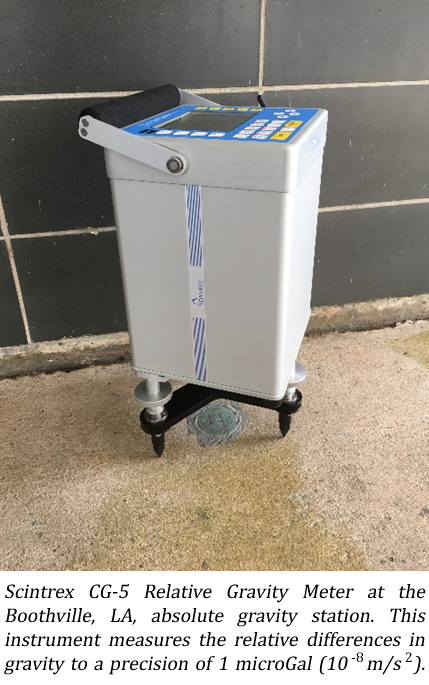
No further observations of Absolute Gravity were performed in the State of Louisiana until 2018 when the National Geospatial-lntelligence Agency returned through the official requests of C4G and the Commander, New Orleans District Corps of Engineers. NGA agreed to visit some of the C4G CORS sites based on personnel availability and scheduling, but their generosity cannot be extended to over 100 of our CORS sites! Our own FG5-X Absolute Gravity meter is now a necessity to support our two CG-5 Relative Gravity meters in our continuing campaign to observe, record, and map the ever-changing gravity field of the State of Louisiana.
 The significance of this research is that traditional surveying methods used to determine elevations of benchmarks have become inordinately expensive in the 21st century, and GPS is the only technology available currently to provide observations for that purpose. The issue, however, is that GPS does NOT provide "elevations" related to the concept of "mean sea level." GPS only provides a geometric "height" with respect to the center of mass of the Earth about which the satellites orbit. A mathematical model of the Earth's gravity field is necessary to translate from "height" to "elevation," and that is called the "geoid model." Where does the geoid come from? It comes from knowledge of the Earth's gravity field.
The more exquisite the knowledge we have about the gravity field, the more accurate we then can model the geoid, providing more reliable elevations for flood insurance, flood control, planning for evacuation route changes based on continuing subsidence, and variations in subsidence rates throughout the State of Louisiana. The LSU GPS Continuously Operating Reference System (CORS) network is a public utility offered by C4G, and that network is dependent on maintaining and improving the knowledge of the geoid for elevation control in support of Louisiana Revised Statute 50:173.1 which names C4G as the State Reference Standard for elevations.
C4G Acquires Geodetic Instruments to Better Understand Subsidence Rates in Louisiana
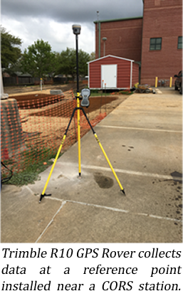
 The Center for GeoInformatics (C4G) in the Department of Civil and Environmental Engineering (CEE) recently received new geodetic instruments to model the Earth’s gravity field. A Scintrex CG-5 Relative Gravity Meter, Leica T60 Total Station, and Trimble R10 GPS Rover Kit were acquired as part of an enhancement grant sponsored by the Louisiana Board of Regents. Drs. George Voyiadjis (PI) and Joshua Kent (Co-PI) led the one-year project, which ended in June, 2017. The instruments are acquired to address the needs of three objectives: First, to develop a novel, high-resolution gravity model of sea level (i.e., geoid); second, to augment knowledge of existing subsidence rates and the driving mechanisms; and finally, promote advanced geodetic research at the University.
Here, as in many river deltas around the world, land surfaces are sinking due to subsidence. On average, southern Louisiana experiences ~10 millimeters per year of subsidence. Understanding the mechanisms that drive subsidence is essential for mitigating risk and promoting sustainability. The CG-5 relative gravity meter supports these goals by measuring the relative differences in the Earth’s gravity across southern Louisiana. Surveys using the total station and R10 rover kit are currently underway to geodetically correlate the CG-5 data with absolute gravity readings collected in the early 2000s by the National Geospatial-Intelligence Agency and the National Geodetic Survey. The updated gravimetric surveys conducted by C4G researchers and staff will deliver much needed insight into the variety of geophysical processes driving the spatially and temporally heterogeneous rates of subsidence measured across the state.
In addition to the subsidence research, this enhancement grant will directly and indirectly benefit Louisiana’s geodetic stakeholder and consumer communities. For nearly a decade, the C4G has provided tools, services, and other geodetic resources dedicated to precise positioning throughout the state and across the region. Central to these resources is the C4GNet real-time reference network. The network includes more than 50 continuously operating GPS reference stations (CORS) installed across Louisiana. Over the next five years, the C4G plans to geodetically correlate the gravity measurements with antenna heights at each station. Exten ded surveys will include CORS in neighboring states. When completed, the data will contribute to the creation of a novel, high-resolution geoid model that will allow the geodetic community to accurately and precisely measure elevations above sea level.
The instruments acquired by this grant represent an investment into the geodetic research capacity at the C4G and CEE. In addition to the above goals and objectives, these resources have already been selected for use by investigators in two external funding proposals, both of which will rely on the precision of these instruments to deliver meaningful geodetic solutions. These instruments not only promote research activities, they have galvanized national and international collaborations with partners across the US Gulf Coast and western Europe.
First Louisiana Gravity Campaign of 2018 Report Completed
The United States National Geospatial-Intelligence Agency (NGA) has delivered its final report of their first Absolute and Relative Gravity Survey of February-March 2018. The survey has been conducted in support of requests from the New Orleans District, U.S. Army Corps of Engineers (USACE) and the Center for GeoInformatics of the Department of Civil and Environmental Engineering, Louisiana State University.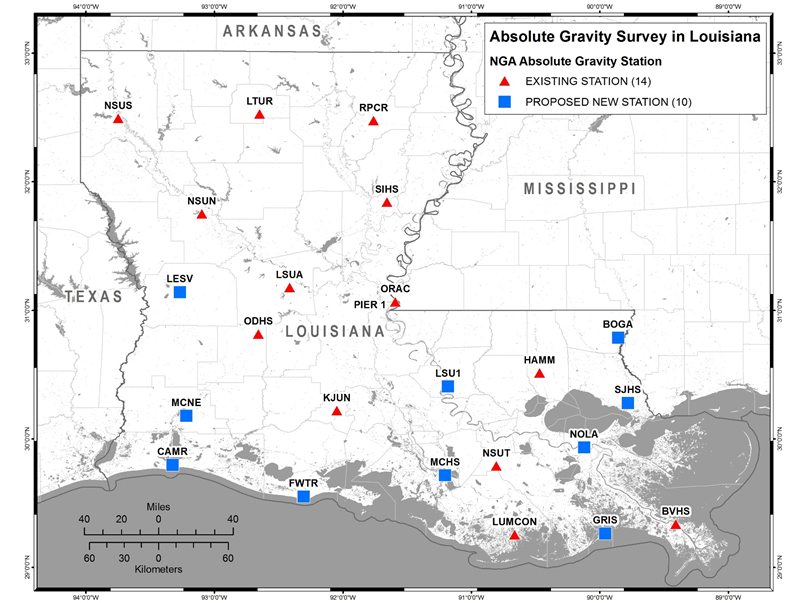
Louisiana is in a known area of geological crustal motion, and most elevation benchmarks are sinking due to a phenomenon of regional subsidence. For centuries, Engineers and Land Surveyors have relied on known reference points known as benchmarks for elevations to determine proper heights for establishing buildings and flood control structures. In Louisiana, those elevation benchmarks continue to subside and the elevations once associated with those points become stale, out-of-date or wrong! Current technology allows surveyors to employ the GPS satellites for a variety of applications, and the determination of elevations is one of the more important applications for the citizens of Louisiana. GPS gives positions that need additional information in order for Engineers and Land Surveyors to determine elevations, and that additional information is the Earth’s gravity field.
The Earth’s gravity field in Louisiana is not precisely known to the exquisite detail necessary for GPS surveyors to determine elevations to fractions of an inch. LSU is in the process of investigative research to better determine the variation of the gravity field in the State of Louisiana. Research into the study of the Earth’s gravity field with respect to subsidence was started in the LSU System in the late 1980’s. The U.S. National Geodetic Survey made the first observations of Absolute Gravity in Louisiana back in March, 1989. Subsequent re-surveys were done in September, 1991, November, 1993, and August 1994. Each time, the observations indicated continuous subsidence in metropolitan New Orleans at a constant rate of 9.1 millimeters per year or more than an inch every three years! These observations are used to understand the rates of subsidence in varying parts of Louisiana, and to monitor any variations in subsidence rates from one observation epoch to another. This is how Engineers and Planners utilize such scientific data in determining future efforts for flood control and disaster evacuation.
NGA has submitted their report on their first gravimetric campaign, and have observed at the LSU campus, the LIGO facility in Livingston Parish, Hammond, Nicholls State University, and the University of New Orleans. NGA personnel will return to Louisiana in the fall for their second gravimetric campaign of 2018. This work represents the second generous donation of time (first time in 2002) and services to the citizens of Louisiana by the United States Department of Defense NGA for the support of flood protection facilities maintained by the New Orleans District, Corps of Engineers.
Click here to read the full National Geospatial-Intelligence Agency (NGA) Report
C4G Acquires FG5-X Absolute Gravity Meter
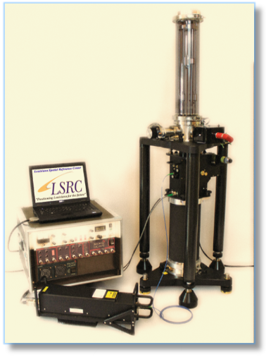
The LSU Center for GeoInformatics (C4G) has purchased and received the first university-owned Absolute Gravity Meter in the Southeastern United States. The importance of this acquisition is that all elevation reference data in Louisiana is subject to subsidence. The federally published values of elevation benchmarks only last 3-5 years in all of South Louisiana, somewhat longer as one goes north. The nation’s engineers and land surveyors are now dependent on GPS observations to get elevation data, but GPS does not provide elevations with respect to local mean sea level (datum); GPS only provides “geometric” heights. A precise knowledge of the Earth’s gravity field is necessary for the conversion from GPS heights into elevations. Flood insurance is dependent on the results of flood elevation surveys performed by engineers and land surveyors, as well as planning for evacuation routes in anticipation of impending hurricane flooding. The Absolute Gravity instrument now held by C4G is the basis for refining the accuracy of the Earth’s gravity field, and by being “absolute,” the instrument employs a basic fundamental reference traceable to the U.S. National Institute of Standards and Technology (NIST).
For decades, the LSU System has relied on Federal Agencies to come into Louisiana from time-to-time in order to observe the changes in the absolute gravity in the State. The U.S. National Geodetic Survey (NGS) first observed absolute gravity in New Orleans in 1989. The NGS has returned over a half-dozen times since then as well as at numerous other sites. Also, with the help of the New Orleans District, U.S. Army Corps of Engineers; the U.S. National Geospatial-Intelligence Agency (NGA) has also performed several absolute gravity campaigns in the State, the most recent one was observed in early 2018. As absolute gravity increases, the changing values indicate actual subsidence of the surface of the observation site and the distance to the center of the Earth. The instrument, an “FG5-X,” made by Micro g LaCoste in Colorado, has a precision of ± one micro-gal (± 1 µg) such that a change of 3 µg = one centimeter (1 cm) in elevation!
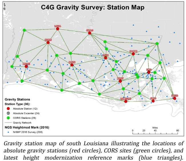
The LSU C4G is the legal standard (Law) in the State of Louisiana for State Government agencies to obtain elevation references per LA R.S. 50:173.1. The C4G has purchased the FG5-X Absolute Gravity meter ($400,000) with C4G self-generated funds – no use of tax dollars contributed to the purchase. The C4G has installed GPS Continuously Operating Reference Stations (CORS) throughout the State as well as at Tide Gauges throughout the Northern rim of the Gulf of Mexico from Corpus Christi, Texas to Jacksonville, Florida. The FG5-X Absolute Gravity meter will be employed to observe at all LSU CORS sites in the future on a continually-revolving basis in order to track the crustal movement of subsidence, its changing values, and the changes in the rates of subsidence. Intermediate points of elevation, the passive benchmarks monumented throughout the Gulf South, will be observed and re-observed by Relative Gravity meters owned by C4G along with the Absolute sites being used as reference standards.
All of these gravity observations, both Absolute as well as Relative will be the basis for the precise mathematical model of the Earth’s gravity field called the “geoid.” The geoid model is the mathematical model of the gravity field that engineers and land surveyors use to convert precise GPS heights into elevations. As subsidence continues to occur in Louisiana and surrounding regions, the actual geoid will change also. This necessitates the continuing observation of the absolute and relative values of gravity in the continual modeling and re-modeling of the geoid. The frequency of repeat gravity campaigns will be determined by experience gained through the monitoring of the gravity observations and the rates of change.