The National Geodetic Survey (NGS) has finished the adjustments to the 2016 South Louisiana Control Update project and will soon have the heights loaded into the NGS database. That loading process will then make the 2016 positional information available to the public...
Welcome to the LSU Center for GeoInformatics (C4G) and Louisiana Spatial Reference Center (LSRC). The C4G was formed in 2001 to build new research and services in Geodesy and GeoInformatics. Over the years, LSU’s C4G has been instrumental to the State of Louisiana;...
 Your Privacy C4G takes your privacy seriously. Please read the following to learn more about our privacy policy. What This Privacy Policy Covers This policy covers how C4G treats personal information that collected and receives, including information related to your...
Instructions for Connecting the Leica SR530 GPS Rover to a SpiderNet, NTRIP or VRS Network with SurvCE and Carlson TCP Relay For users of Carlson’s SurvCE product wishing to connect to a reference network that requires a GGA position message sent from the rover to the...
The Center for GeoInformatics proposed the CORS station at Loyola University (New Orleans) for inclusion into the National CORS network. This will bring greater integration and ease of access for Louisiana users, including OPUS and archival services available through...
Your Privacy C4G takes your privacy seriously. Please read the following to learn more about our privacy policy. What This Privacy Policy Covers This policy covers how C4G treats personal information that collected and receives, including information related to your...
Instructions for Connecting the Leica SR530 GPS Rover to a SpiderNet, NTRIP or VRS Network with SurvCE and Carlson TCP Relay For users of Carlson’s SurvCE product wishing to connect to a reference network that requires a GGA position message sent from the rover to the...
The Center for GeoInformatics proposed the CORS station at Loyola University (New Orleans) for inclusion into the National CORS network. This will bring greater integration and ease of access for Louisiana users, including OPUS and archival services available through...
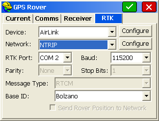 GETTING CONNECTED The last newsletter provided “general” informa- tion about using the Internet to transfer RTK data to a GPS user and also described the features and benefits of using NTRIP. This newsletter continues with this topic, but focuses on how to configure...
Supplementary Notes to the System1200 Firmware 1.52 Release Notes With System1200 firmware version 1.52, it is possible with GPS1200 to access the Internet and to use Internet Services such as the Network Transport of RTCM via...
GETTING CONNECTED The last newsletter provided “general” informa- tion about using the Internet to transfer RTK data to a GPS user and also described the features and benefits of using NTRIP. This newsletter continues with this topic, but focuses on how to configure...
Supplementary Notes to the System1200 Firmware 1.52 Release Notes With System1200 firmware version 1.52, it is possible with GPS1200 to access the Internet and to use Internet Services such as the Network Transport of RTCM via...