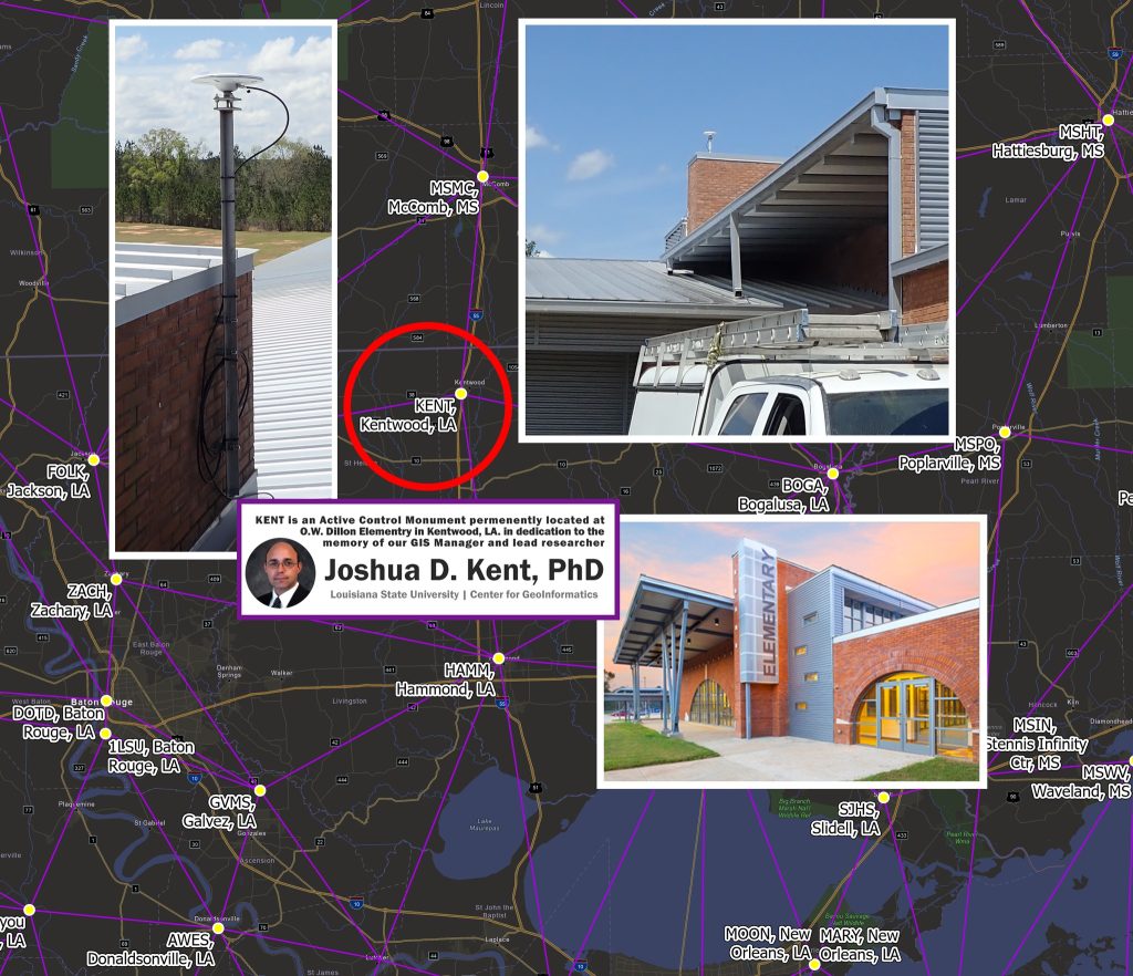
 The KENT station, an Active Control Monument in Kentwood, Louisiana, has been established as a permanent Active Control Monument to honor the research contributions of Joshua D. Kent, Ph.D., at C4G and to ensure lasting recognition of his scientific legacy.
In the heart of Kentwood, Louisiana, the monument named KENT serves as a vital symbol of scientific precision and a profound tribute to the remarkable intellect and passion that Joshua D. Kent, Ph.D., contributed to geoinformatics; his unwavering commitment to advancing knowledge and fostering innovation within the academic community continues to inspire those dedicated to uncovering the mysteries of our environment, acting as a source of motivation for future researchers who will regard this monument as both a scientific resource and a homage to a life wholeheartedly devoted to inquiry and exploration. Josh's unexpected passing in the prime of his life and academic career left a significant void at the LSU Center for GeoInformatics.
Continuously Operating Reference Stations, or CORS, serve as the backbone of advanced positioning techniques and function as Active Control Monuments that document their positions every second. The data amassed from these stations is utilized in numerous scientific research endeavors, many in which Josh was intricately involved. By naming one of our stations in his honor, we aim to create a lasting testament to his enduring influence in the field of geoinformatics and a permanent tribute to his remarkable research legacy at the LSU Center for GeoInformatics.
Purpose of the KENT Monument
Active Control Monuments serve as a fixed reference in geodetic and environmental research, providing a reliable point for measurements and monitoring. KENT, in Kentwood, LA, symbolizes both a functional scientific tool and a commemorative dedication to Dr. Kent’s work. And highlights personal achievements but also inspires continued excellence in the field, offering future researchers a tangible point of reference tied to a human legacy.
These monuments are critical in maintaining consistent and accurate spatial data across research projects, and the data they generate are permanently marked with the name of the monument for ongoing scientific reference, ensuring that Dr. Kent’s contributions at C4G are recognized for generations to come.
Legacy of a Spirit of Inquiry
Josh's research made significant contributions to his field, illuminating complex theories and methodologies that inspired both peers and students alike. His academic journey was marked by a series of prestigious awards and recognitions, showcasing not only his commitment to excellence but also his profound impact on the academic community. With a passion for knowledge and discovery, Josh published numerous articles that have been widely cited, reflecting his innovative approach and relentless pursuit of understanding. His legacy lives on through the insights he shared and the lives he touched, embodying a spirit of inquiry that will continue to inspire future generations.
The following is a detailed summary of Josh's academic and professional history as noted in his most recent CV prior to his passing.
Joshua D. Kent, Ph.D.
GIS Manager / Post-Doctoral Research
LSU Center for GeoInformatics
Research Interests
Josh's research interests included the spatial analysis of dynamic phenomena (e.g., crime, natural disasters, demographics, coastal morphology, transportation planning, etc.), implementation of geo-statistical processes, Web mapping applications, spatial data visualization, and enterprise GIS/GIT systems design.
* Criminal Geoforensics & Geographic Profiling
* Geospatial Intelligence
* Geospatial Modeling
* Emergency Response & Hazard Mitigation
* Geospatial Visualization
* Web Mapping Services & Enterprise GIS Implementation
Education
Doctor of Philosophy in Geography (2009), Louisiana State University, Baton Rouge, LA
Master of Natural Sciences (2003), Louisiana State University, Baton Rouge, LA
Bachelor of Science (1994), Louisiana State University, Baton Rouge, LA
Research Projects
Gulf Coast Evacuation & Transportation Resiliency Grant (2010 – 2011), Principal Investigator
Funded research to assess the long-term impact of subsidence and global climate change on emergency evacuation routes in coastal Louisiana.
State Emergency Evacuation & Sheltering Plan (2010), Technical Lead
Unfunded research to provide mapping and technical support for emergency evacuation management and shelter site-selection for the State Office of Homeland Security and Emergency Preparedness (GOHSEP).
State Hazard Mitigation Plan Advisory Board (2010), Technical Reviewer
Review and advise the Louisiana State Hazard Mitigation Planning Committee with updates for the statewide plan; technical reviewer of data and methodologies.
Gulf of Mexico Oil Spill Response (2010)Technical Lead
Support parish and State government efforts to locate and map oil infiltration in marshes and bays along coastal Louisiana.
Louisiana Virtual Coast (2010), GIS Data Manager
Online spatial data service and archival repository for geospatial data assets collected for research and analysis of Louisiana's coastal zone.
Multi-Agency Homicide Investigative Taskforce (2009 –), Geospatial Services & Geo-forensic Profiling; Co-Investigator
Unfunded research to provide mapping and geo-forensic analysis to the multi-agency serial homicide task force created for Acadia, Calcasieu, and Jefferson Davis parishes. Coordination through the State Police Crime Lab.
South Lafourche Levee District: Elevation Survey and Visualization (2009), Spatial Data Visualization: Developer and Technical Lead
Designed a 3-dimensional virtual landscape for a preliminary elevation survey conducted for the South Lafourche Levee District (SLLD). Compose a video of the virtual flyover. Examples online: Web Link, and with Legend Web Link
Courses
CE 4560 - Engineering Applications to Remote Sensing Instructor, Dept. of Civil & Environmental Engineering, Louisiana State University - Baton Rouge, Louisiana.
ENVS 4149 - Environmental Management Systems - A GIS ApproachInstructor, Adjunct Faculty, Dept. of Environmental Sciences, Louisiana State University - Baton Rouge, Louisiana.
ENVS 4262 – Environmental Hazards Analysis Instructor, Adjunct Faculty, Dept. of Environmental Sciences, Louisiana State University - Baton Rouge, Louisiana.
GEOG 4048 - Methods of Spatial Analysis Special topics guest speaker, Department of Geography & Anthropology, Louisiana State University - Baton Rouge, Louisiana.
Classroom Training (2003–2008), Technical Trainer, LAGIC - Baton Rouge, Louisiana.
Select Publications Selected Refereed Journal Publications
* (2011) Kent, J. and Dokka, R. "Realizing a Spatially Accurate Incident Reporting System during the 2010 Gulf of Mexico Oil Spill Disaster". Journal of Environmental Management. Vol. 9, No.4, p69-79. ISSN1543-5865; DOI:10.5055/jem.2011.0068
* (forthcoming) Kent, J. and Leitner, M. "Incorporating Land Cover within Bayesian Journey-to-Crime Estimation Models".
* (2011) Leitner, M., Barnett, M., and Kent, J. "The Impact of Hurricane Katrina on Reported Crimes in Louisiana - A Spatial and Temporal Analysis". Professional Geographer. 63 (2): 244-261. DOI: 10.1080/00330124.2010.547156
* (2009) Leitner, M. and Kent, J. "Bayesian Journey-to-Crime Modeling of Single and Multiple Crime-Type Series in Baltimore County, MD". Journal of Investigative Psychology and Offender Profiling. Vol. 6, pp. 213-236. DOI: 10.1002/jip.109
* (2009) Kent, J. and Leitner, M. "Utilizing Land Cover Characteristics to Enhance Journey-to-Crime Estimation Models". Crime Mapping: A Journal of Research and Practice. Vol. 1, No. 1. , pp. 33-54. ISSN: 1942-0927
* (2007) Leitner, M., Kent, J., Oldfield, I., and Swoope, E. "Geoforensic Analysis Revisited - The Application of Newton's Geographic Profiling Method to Serial Burglaries in London", UK. Police Practice and Research: An International Journal. Vol. 8, No. 4, pp. 359-370. DOI: 10.1080/15614260701615060
* (2006) Kent, J., Leitner, M. & Curtis, A. "Evaluating the Usefulness of Functional Distance Measures When Calibrating Journey-To-Crime Distance Decay Algorithms", Computers, Environment, and Urban Systems. Vol. 30, pp. 181-200. DOI:10.1016/j.compenvurbsys.2004.10.002
Conference Presentations & Posters
(2011) Kent, J. and Dokka, K. Spatially Accurate Incident Reporting System During the 2010 Gulf of Mexico Oil Spill Disaster. Poster presented at the Deepwater Horizon Oil Spill Conference: Research from the Four University Consortium & LUMCON. Baton Rouge, Louisiana. [link]
(2011) Kent, J. Visualization Models of Anthropogenic Subsidence Across Coastal Louisiana: Communicating Subsidence Using 3D Visualization. Guest Seminar Series – School of the Coast & Environment, LSU. Baton Rouge, LA.
(2010) Kent, J. Incident Reporting System for the Gulf of Mexico Oil Spill Disaster. The 2010 Trimble Dimensions Conference. Las Vegas, NV. [link]
(2010) Dokka, R., Mitchell, J., Kent, J. Techniques for Collecting and Assessing Elevation Data Across Southern Louisiana. The 2010 Trimble Dimensions Conference. Las Vegas, NV. [link]
(2010) Dokka, R., Kent, J. Understanding the Late 20th Century Subsidence of New Orleans with Geodesy, Geology, and Tide Gauges. Presentation for the 2010 International GNSS Service Workshop and Vertical Rates Symposium. June 2010, Newcastle, England, UK. [link]
(2010) Kent, J. and Dokka, R. A Landscape of Unintended Consequences – Future Subsidence Trends across Southern Louisiana. Presentation for the 6th Annual Roy J. Shlemon Specialty Conference: Modern Subsidence, Sea-Level Rise, and the Future of the Gulf Coast, sponsored by the Association of Environmental & Engineering Geologists. May 2010, Galveston, Texas.
(2010) Kent, J. and Leitner, M. Innovative Research and Applications in Geographic Profiling. Presentation for The 26th Annual Louisiana Remote Sensing and Geographic Information Systems Workshop. April, 2010, Lafayette, Louisiana.
(2010) Kent, J. and Dokka, R. Anthropogenic Subsidence along Coastal Louisiana. Presentation for The 2010 Annual Meeting of the Association of American Geographers. April, 2010, Washington, DC.Other Publications
(2006) Kent, J. and Underwood, N. Southern Louisiana Diaspora: Population Evacuation Patterns Following Hurricanes Katrina and Rita. 22nd Annual Louisiana Remote Sensing & GIS Workshop. Baton Rouge, LA. April 4, 2006.
(2005) Kent, J. 2005 Louisiana Hurricane Impact Atlas, Volume 1. Louisiana Geographic Information Center, Baton Rouge, LA. [link]
Professional & Academic Associations
* Association of American Geographers (2007–current)
* Louisiana Remote Sensing & GIS Workshop Coordination Committee (2005–2009)
* National States Geographic Information Council (2001–2004)
Awards & Certifications
FEMA Emergency Management Institute (2010) Certificates of Achievement:
Independent Study Courses; IACET CEU:2.0
Distinguished Dissertation Award Finalist (2009), Louisiana State University, Baton Rouge, Louisiana
Staff Senate Fee Support Scholarship Award (2009)
Scholarship for LSU staff pursuing academic degrees
Special Achievement in Remote Sensing & GIS (2008)
Louisiana Hurricane Impact Atlas 2005 Vol.1 (Kent, 2005) and Louisiana Hurricane Diaspora (Kent & Underwood, 2006)