C4G Frequently Asked Questions
Real-Time Network FAQs
-
WHAT IS C4GNET.XYZ REAL-TIME NETWORK?
LSU has implemented C4GNet.XYZ as a Real-Time-Network (RTN) that allows subscribers to enjoy a virtual zero-length baselines everywhere in Louisiana. Rather than using radios to transmit correction data from a single reference station, C4GNet.XYZ uses the entire network of 130+ CORS receivers to compute the atmospheric corrections that are necessary for where the subscribed user is located! Using cellular data service, the C4GNet.XYZ RTN keeps track of where each mobile user is located, and as users move the system will re-calculate corrections as needed to maintain the benefit of a continuous, zero-length baseline.
-
I Can’t Connect, Has My Login Been Turned Off?
Your ability to connect to the RTN will automatically shut off if your subscription expires until a new subscription is activated. However, three automated emails will be sent to the email address in your RTN profile on the C4Gnet.XYZ portal website prior to this happening. The notices go out 30 days prior to the expiration, 10 days prior to expiration, and again when the subscription expires. Many report not receiving these notices, which is usually due to email security blocking the notices or the wrong email listed in your C4Gnet.XYZ profile. You can check your Active Subscriptions or Personal Data, where the email address that automated notices are sent to is located, by logging into the C4Gnet.XYZ portal website. Contact C4G if you suspect this has happened to your account and you need help, or go to the C4G Webstore and place an order for a new subscription, as payment will trigger the reactivation of your account.
Another thing that could trigger your connection to fail is if you attempt to log in with an incorrect password 10 times, your account will be automatically locked and a notice will be sent to the contact email listed in your C4Gnet.XYZ profile. In that case, contact us immediately, and we will reset it for you.
If neither of these reasons is in play and you still cannot log in, you may need to investigate the reasons discussed below.
POOR CELL ENVIRONMENT
FORGOTTEN USERNAME AND/OR PASSWORD
NETWORK OUTAGE
SCHEDULED MAINTENANCE -
I Can’t Connect, Is There Something Going On With The Network Today?
Very rare since we operate three redundant systems that are identical without any differences in performance. Users connecting with the C4Gnet.XYZ DNS as the network host address, automatically get routed to our Primary RTN servers. If there is a problem on the Primary RTN servers, users are automatically sent to the Backup RTN servers. If the entire Primary/Backup hosting location is offline users are routed to the C4G Backup servers located at our LSU offices. So the rover shouldn’t see down time due to our RTN reduncency.

The quickest way to see if there is an issue with the C4Gnet.XYZ RTN system is to open the sensor map located at http://c4gnet.xyz/Map/SensorMap.aspx. You do not need to log in to the web portal to see the sensor map, but its a good way to test your login and confirm it is working properly.
-
Are You Doing Maintenance On The System Right Now?
System maintenance should never interrupt the RTN as our three-tier redundancy allows us to route all connections to any of the three RTNs while we do updates on the others. Updates are also done after hours and typically on weekends (e.g., monthly security patches). For whatever reason that one of our RTN servers might be down (individual server uptime is over 98%) it is extremely unlikely that all three RTNs would be down at the same time. Make sure your crews use the DNS C4Gnet.XYZ instead of an IP address to contact our NTRIP casters so that they can automatically be routed to the best quality of RTN service using our three-tier RTN redundancy architecture.
-
My Logins Are Ok, And The Network Looks Ok, Why Can’t I Connect?
This is almost always related to cellular service. It can be frustrating as you may see bars on your phone, voice works OK, and it may have worked OK on a different day, but that does not necessarily mean that data is steaming well enough where you are at that time. One easy check is to open a browser on your field data collector and navigate to a website (choose one that changes a lot, as you may see a cached page otherwise). Another tool is a cell status app, like Network Cell Info Lite, that shows the signal strength in detail (for instance, a value of -100 dBm – 110 dBm often means spotty data streaming, and -110(+) dBm can mean no data streaming). Because voice has priority over data, even though you show bars and have voice service, the data streaming may be spotty or not flowing. This can be due to high voice traffic at the time and area you are located and it can pass just as fast as it happens. iPhone users can also view a native analysis tool by cutting/pasting or typing *3001#12345#* into the phone dialer; this will show much the same info as the abovementioned app.
-
I Forgot My Username And/Or Password, Can You Give Them To Me Again?
Please keep a copy of your credentials email handy and give one to your crews. And it’s always good practice to test your gear before going to the field. We can help if you are stuck in the field and forgot your password, but it might take some time. With the new security protocols, all passwords have been encrypted, so we can no longer see the passwords in the system. We may have email copies of the original credentials we sent you, and we can try searching for those, but if we can’t locate the password that way, we will have to reset your password to something new that is at least 8 characters.
The RTN web portal has a link to start a password recovery process that is difficult to complete, especially when you are in the field.

If you need help with the “Forgot your password?” process, contact C4G, and we can execute it for you and reset the password to anything you want it to be that is a minimum of 8 characters.
-
What Can I Do In A Poor Cell Environment?
You are always at the mercy of the cellular coverage; it might be poor in some areas all the time and somewhat usable on other days or at different times of the day. The cell coverage maps from the main carriers are not always accurate but can give you a general idea. The carriers have been rapidly upgrading their systems and coverage. There are apps that show cell tower locations and what carriers are on each tower. If you have a built-in modem, see if you have the option of connecting an external cell antenna. It is hard to keep up with which carrier works best in which region of the state, which continues to evolve. C4G has no cell coverage map; the situation moves too fast, and it is impractical to comprehensively try to test across the state. We rely on user feedback, and some note that they can now get cell service in areas they could not even a few years ago.
We do get asked if there are ways to improve the signals, like with boosters. From user feedback: some carry phones/modems for two or more carriers if they work in multiple areas across the state. Some users who use their phone as a hotspot or have a portable WiFi hotspot will put those on a telescoping rod to get some elevation; it is surprising how an extra 10’ can improve cell reception in some places. If you have a built-in modem, see if you can connect an external cell antenna. Some WiFi hotspots come with an external antenna jack (SMA coax connector). There are large dipole cell antennas and directional (yagi-style, that you can point at the nearest cell tower). Adding a booster to the mix may also help: if you have RF ‘garbage’ coming, the booster may just amplify the ‘garbage’. In marginal cell areas, a booster can help, but it can be hit or miss. The in-line boosters work better than proximity-styler boosters. An effective booster can cost hundreds of dollars and needs its own power source.
We use in-line boosters for many of the reference stations, but those are fixed locations where we test and set up the right antenna for the location.
There is a hybrid solution called an Ethernet Bridge, like the ones made by Intuicom. These devices deliver rock-solid connectivity and consistent RTK connections, whether from a Base Station or Network. These devices work by placing the Ethernet Bridge in a location where the cell coverage is good, and it relays the connection by radio to one or many rovers. While these can be a bit expensive, they are a great tool to have when cell coverage is interrupting your productivity.

We have tested a last resort option for spotty cell areas: switch to single-base (but there are trade-offs). The reason this might work is that single base does not require consistent bi- directional communications with the RTN like VRS does; a single base solution is a request that starts the flow, and if there are gaps in the flow, your rover will simply wait until it has enough data. The one big caveat is that if you are in an area with poor cell, there is likely not a reference station nearby, and the long-baseline, single base solution may be poor quality and inconsistent.
A key recommendation from users who encounter poor/no cell areas: collect static and or PPK and post-process or use one of the commercial precise point positioning (PPP) services that broadcast from L-Band satellites (lower precision, especially in the vertical, but good in a pinch). C4Gnet.XYZ has an online post-processing service for static observations (not PPK) for anyone requesting a free account; see more below.
-
My Positions Are Off By Several Feet, What’s Up?
If you see values off by about 4 feet horizontally, it is most likely due to a datum transformation issue. GPS/GNSS is referenced to WGS/IGS/ITRF, and the values you typically want to work in are NAD83 (i.e., the current National Spatial Reference System framework). These are two different ellipsoids, separated by about 2m at the earth’s center, which means different global separations. Your field software does a transformation on the fly (i.e., the Molodensky transformation). This issue is usually in your rover settings. C4Gnet.XYZ is constrained to NSRS (currently NAD83- 2011), and in some brands of field software, you have to choose “No transformation,” or you will be double transforming, which is about 4 feet horizontally. For example, in some Topcon field software, you choose “No Transformation,” and in some Trimble software, you choose “NAD83” and not “NAD83-2011”. Consult with your equipment vendor if you need help on how to make these setting changes in your rover. If your orthometric elevation values are off between 60-80 feet, that indicates that a geoid model is not being applied in your field software. Again, consult with your equipment vendor on how to add the current geoid model to your rover. The C4G website also has some GEOID Tools that you might find helpful.
-
Why Are My Positions Off By Several Tenths Compared To Published Control Values?
The Earth is dynamic. Differences may be due to the age of the published values and/or the methods used to establish them. Due to much of Louisiana being prone to subsidence, for example, a position in a subsidence zone may have changed by an unknown amount over a 25-year period, and the published values could be stale versus what you measure today. Published values may have been established with legacy methods or reference frameworks that do not have the same network accuracy as more recent ones. Plus, the marks may have been set 25, 50 or 60 years ago, and there may be many reasons why they might be suspect. We suggest doing check shots on recently published NGS or LADOTD marks with NAD83-2011 values. You may wish to use a “localization” or “calibration” (it is called different things in different vendors’ field software) routine if you need to constrain your project to old, published values.
-
What Datum, Or Reference Frame Does C4Gnet.XYZ Work In?
C4Gnet.XYZ is constrained to the National Spatial Reference Framework (NSRS) of the National Geodetic Survey (NGS). Currently, this is NAD83-2011 Epoch 2010.00. Vertically, C4Gnet.XYZ is constrained to the NSRS, and results are expressed in ellipsoid heights. Orthometric elevations, like NAVD88 are derived in your field or office software by applying a geoid model, For instance, GEOID 2018 from the NGS. We recommend using whatever the latest geoid model is from the NGS. You can obtain the geoid files from the NGS or your GNSS rover vendor. The C4G website also has some GEOID Tools that you might find helpful.
-
Does C4Gnet.XYZ Provide Me With State Plane Coordinates?
No, C4Gnet.XYZ works purely in geographic references. Any plane projections are done in your field or office software. You should talk to your GNSS vendor about how to set that up in your field software.
-
Does C4Gnet.XYZ Provide Grid Or Ground?
No. These are handled in your field or office software, all GNSS observations collected with C4Gnet.XYZ are Lat/Lon plus ellipsoid height only.
-
Does C4Gnet.XYZ Provide Projections?
No, the data provided by C4Gnet.XYZ is satellite data oriented in the datum chosen by the user, usually NAD83 in Louisiana. The second most chosen datum is ITRF.
Projections are the method used to “project” positions from the “round” earth onto a flat plane so it can be mapped on a sheet of paper. There are many and they range from super-simple to ridiculously complex depending upon the purpose.
When a surveyor makes a plat of a piece of property and assigns a coordinate to one corner (say X=1000, Y=1000, Z=100) and draws the property on the map he has created a local projection – super-simple.
When scientists want to compare land or water areas, or NASA wants to plot satellite orbits, more complex projections are used.
The standard projections used for most surveying and mapping in the U.S.A. are State Plane Coordinates. These have been promulgates since the early part of the 20th century for NAD27, revised after NAD83, and are being readied for NATRF22. These may usually be found in users’ software (PC or DC) and chosen from a list.
(At this moment (May 26, 2024), the legislation for the Louisiana Plane Coordinate system has passed both houses of the legislature and is scheduled for concurrence on 05/28/2024.)
Once signed, it will become effective when the NGS/NOAA promulgates NATRF 2022 and thereafter:
“The official geodetic datums for geodetic coordinates referenced within the state shall be as defined by the National Spatial Reference System established by the National Geodetic Survey of the National Oceanic and Atmospheric Administration, or its successors.”
-
What Hardware And Software Are Needed To Use C4Gnet.XYZ?
You need a high-precision-grade GPS/GNSS receiver and antenna, either in the form of a standard “rover” or other receiver and antenna combinations. The receiver needs to be capable of using external corrections and can track at least GPS satellites or multiple constellations (e.g., combinations of GPS, GLN, GAL, BDS, etc.). To receive corrections from C4Gnet.XYZ, you will need internet connectivity, typically via a cellular connection. You will need field software that supports your GPS/GNSS hardware and supports NTRIP connections (for more details, see WHAT is NTRIP.
You must set that up with a cellular carrier directly (C4Gnet.XYZ does not do this) and use a modem or phone with a data plan. Some rovers have a modem built into the rover head, others have a modem in the field data controller, and other users work in an app on a phone. Some users prefer a portable WiFi “hotspot”, and connect their controller to it via WiFi, while others use their phone as a hotspot. You must have a data plan with a cell carrier in any scenario. Nearly all field software or apps for surveying/mapping are set up for NTRIP protocols. If it does not, there are free apps that can receive corrections and pass them to a receiver, but you will still need a cellular data plan.
-
What Do You Mean By VRS, PPP, and NSB?
VRS is a type of network RTK (NRTK) processor that uses data from multiple stations surrounding the area you are working and creates corrections modeled for your location to send corrections as if you have a base right next to you with a near-zero baseline length.
PPP mountpoints use a different type of network processor called RTXNet that delivers the next generation of real-time GNSS network modeling and makes it possible to take full use of all available GNSS signals, i.e. – GPS, GLONASS, Galileo, Beidou and QZSS. Rovers wishing to take advantage of these additional Satellite Vehicles (SV) must connect to a PPP mountpoint that delivers corrections in CMRx or RTCM 3.2 with Multi-Signal Message (MSM) format. Rovers connected to PPP mountpoints are sent corrections based on advanced Precise Point Positioning (PPP) processing algorithms to combine RTX corrections with local measurements and produce cm-level accurate absolute positions.
NSB or Nearest Single Base is where differential-style corrections are from one individual station. In C4Gnet.XYZ NSB mountpoints the rover is connected to a single base that is closest to where they are working. One drawback of single base is that results degrade over distance, typically increasing greatly at distances of 10km or more. The rover must monitor how far away they are from the base station they are using to mitigate the amount of error in the data they collect. Real-time networks globally found that network-based RTK allowed for much greater station spacing; it would be impractical to be able to afford to build a network with 10km spacing. However, VRS and PPP can be spaced at 30km-70km (depending on local conditions), which was the original impetus behind developing network corrections and Real-Time Networks.
-
Can You Help Me Set Up My Rover?
In short, no. While we will try to help, we are not versed in every hardware/software combination, which is more rightly the responsibility of the GNSS dealer that sold you the rover through whatever support arrangement you have with them. When you receive login credentials from us via email when you first start working with C4Gnet.XYZ includes the key things you will need to put in the settings of your field data collector software, like the NTRIP host address, port, username, and password. In general, you are looking for any screen in your software with keywords like ‘NTRIP’ or ‘Network’, ‘Corrections’, or ‘Caster’.
Through years of support calls, we may have a general idea of what different manufacturers call different settings in their software, and we will try to help if we can, but the best bet for settings help is to ask the vendor first. If the vendor gives you the new gear with the settings preset, we recommend you go over those (in detail) with them. Becoming familiar with the settings and how to change them if needed can help avoid getting stuck in the field trying to figure things out. For example, if someone has changed your settings or if you need to change them for other reasons.
-
Where Do I Find The Current Positions Of The Stations (E.G., For Post-Processing)?
You can go to the sensor map and click on any station, then choose the info tab. That will list the live NAD83-2011 Epoch 2010.00 position and ellipsoid height of the antenna reference point (ARP) of the station. Users may need this if they are doing their own post-processing.
-
What Do The Different Color Dots On The Sensor Map Indicate?
On the sensor map,
greenindicates that the station is connected and in solution. Yellow indicates that we may have a connection, but that there may be an issue with data completeness, spotty comms, or data quality and that it does not presently meet standards for inclusion in the solution. Red means we have lost connection altogether for the time being. You will also see additional layers (see key below) that we have added to indicate things such as coverage areas, NGS National CORS, single base, network CORS, network geometry and locations planned for future CORS to be deployed.
Orange Dots – CORS in Network Solutions
Purple Dots – CORS Providing Single Base Solutions
Purple Rings – Single Base Coverage Area
Light Blue Ring – Network Coverage Area
Dark Blue Rings – NGS Adopted CORS in the NCN
Grey Lines – RTN Geometry (smaller polygons = more robust coverage)
Teal Plus Signs – Area targeted for future CORS deployment to shrink polygons -
Why Is That Station Down?
Often, site outages can be attributed to spotty comms that usually get better in a matter of hours or a day. We can remotely fix many issues, but sometimes a site visit is required to diagnose a problem. Fortunately, even if individual stations are down, the network solutions (VRS and PPP) are usually robust enough to cover the area of a station outage, another reason why the C4Gnet.XYZ RTN was developed.
-
Is C4Gnet.XYZ Multi-Constellation?
Yes. All C4G CORS support four constellations: GPS (U.S. Navstar), Glonass (GLN), Galileo (GAL), and BeiDou (BDS). Rovers using C4Gnet.XYZ mountpoints with “GREC” in their name can use these additional satellite vehicles (SV) in their solutions. VRS mountpoints only support GPS and GLN, so rovers need to connect to a mountpoint that starts with PPP followed by GREC that delivers corrections in CMRx or RTCM 3.2 with Multi-Signal Message (MSM) format to use these additional SVs.
-
What Does ‘MSM’ Mean?
This means ‘multi-system message’, a term used for RTCM corrections that support multiple constellations. We use MSM in all of our mountpoints that support RTCM3.2 or RTCM3.4 format that nearly all newer rovers can use. This is the format we recommend users of newer gear use so they can take advantage of as many satellites and signals as possible.
-
Can I Try Out C4Gnet.XYZ?
C4G provides GNSS dealers with demonstration accounts intended to be used to allow their clients to try out C4Gnet.XYZ. Since these GNSS dealers are familiar with your equipment and software, it is best to contact them as they can support and guide you through the setup of your rover and give you access to C4Gnet.XYZ through the use of their demo accounts.
-
What Is NTRIP?
You will likely see this term in the settings of your field data collector software. NTRIP is ‘Network Transport of RTCM over Internet Protocol’. It is an international standard for accessing real-time network (RTN) data. It was created decades ago by the BKG (German geodetic and mapping agency) when RTN was first developed and adopted by the International Radio Technical Commission for Maritime Services (RTCM) 104 committee. The core code has been adopted by GPS/GNSS manufacturers. NTRIP consists of ‘caster servers’, like those C4Gnet.XYZ and all RTN hosts that allow multiple users to access multiple ‘sources’, or ‘mountpoints’. One analogy for NTRIP is that it is like an app that connects to a web service listing many streaming music or video channels, but with GNSS corrections instead.
The other component of NTRIP is the ‘client’; The software in your field controller is the client. Required settings are a caster server, typically an IP address of a single caster server, but we use the Domain Name System (DNS) instead, which lets us redirect users to different servers without any changes to end user settings, a port (eg, ‘9000’ for C4Gnet.XYZ), a user name and password, and you choose a mountpoint. See our mountpoint naming convention guide. Often, the field software builds a list of mountpoints each time you access the NTRIP caster; In some software, you need to refresh the list manually. Depending on the software, if you choose single-base or network (eg, VRS or PPP) you will see different lists depending on the settings in your roofs field software.
-
Why Are There So Many Different Mountpoints On The List?
We need to offer different standard formats of corrections to serve a wide range of rovers, new and old. A mountpoint defines the type of processor used, what satellite constellations are supported, the format of the correction messages, and the reference frame used in the real-time data stream.
For instance, CMR+ (GPS+GLN) for some rovers, RTCM3.1 (GPS+GLN) for other rovers, and RTCM3.2 with MSM (GPS+GLN+GAL+BDS+QZSS) for multi-constellation rovers and CMRx (GPS+GLN+GAL+BDS+QZSS) which only works with Trimble multi-constellation rovers. You should not see any significant difference between results from any of the formats, except that some support more satellites and the ones that start with NSB use just a single base and you will need to watch how far you get from the base as ppm errors increase as you do. See our User Guide or our NTRIP and Mountpoints page for more details on mountpoint names.
-
I Can’t Connect. Am I Being Jammed?
The short answer is no. Deliberate jamming is rare and usually occurs only in combat zones. Even in those instances, it is very localized, focused, and brief. Things like jamming, interference, and spoofing are extremely rare. We have only verified a handful of instances in all the years C4G has been operating its Real-Time Network. Examples are mostly related to altimeter radar at the end of large runways; it only happens when that is turned on for a plane to land, it is brief, and it simply blanks out any GPS/GNSS reception. Another was near the Pilot Station at the Southwest Pass of the Mississippi. Working under high-power transmission lines is usually OK, but there have been some rare occasions where it messes up the cell and GPS/GNSS signals.
Other RF interference is rare, and there are no persistent areas of interference that we have been able to verify. Interference, when present, would mostly result in a denial of service and not a false position. A map of persistent interference/jamming zones can be found at GPSJAM.ORG. Incidents of suspected GPS issues should be reported to the US Coast Guard Navigation Center: NAVCEN, where they are investigated by multiple federal agencies. Spoofing is when a party deliberately overrides signals to create false positions. It is rare, difficult to do, and would result in values being many miles off, and not just a few tenths.
There are signal jammers like the cheap “trucker jammers” that some people have used to jam their on-board GPS to block being tracked. This is very rare and highly illegal, and only a few cases have been confirmed (nationwide). Plus, the vehicle with the jammer is moving, and you might not notice the few epochs of outage as it passes.
We have spectrum analyzers on our reference stations (and have never seen any persistent interference), which we can use to investigate areas of suspected interference if need be.
-
Can Solar Storms Mess Up My Results?
Yes. Though relatively rare, please note the solar cycle info below.
Solar Cycle 25.
We are approaching the peak years of the latest solar cycle (the 25th since the phenomenon was tracked), which coincidentally will peak in 2025.
Below is NOAA’s current Solar Cycle Progression: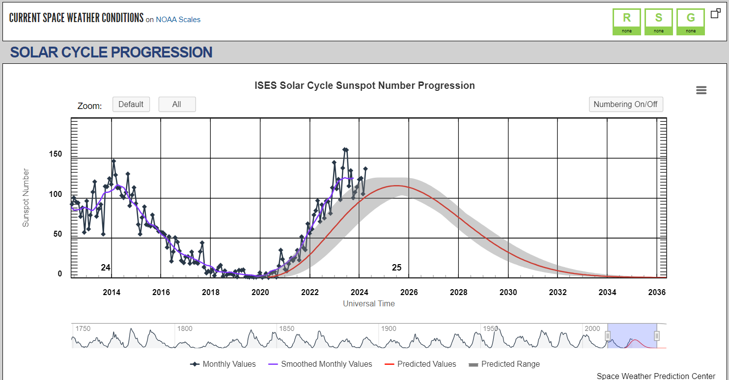
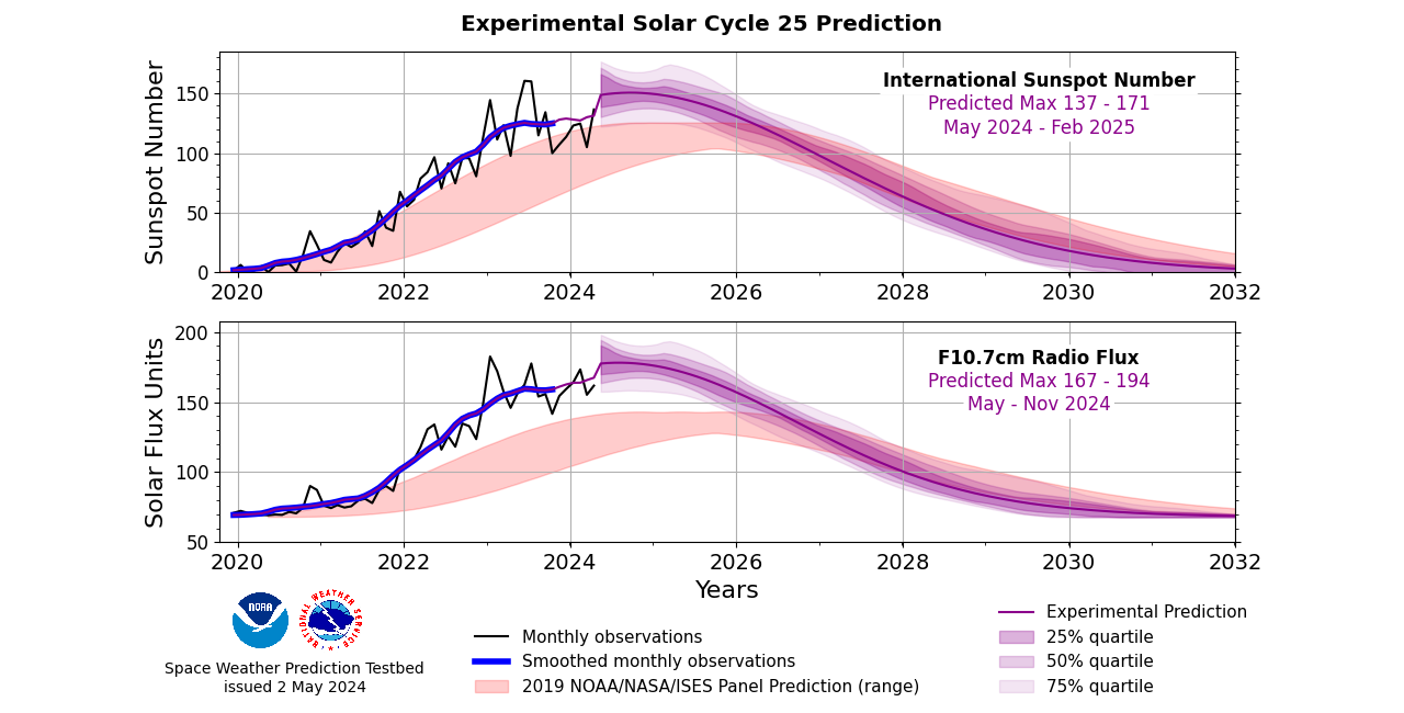
NOAA’s Space Weather Prediction Center released a revised prediction for solar activity during Solar Cycle 25. The new Experimental Solar Cycle Prediction issued on May 2, 2024 concludes that solar activity will increase more quickly and peak at a higher level than previously predicted The updated prediction calls for Solar Cycle 25 to peak between May and Febuary of 2025, with a maximum sunspot number between 137 and 171. (NOAA)
FORECASTS
SWPC produces forecasts for multiple space weather phenomenon types and the resulting impacts to Earth and human activities. A variety of products are available that provide these forecast expectations and their respective measurements in formats that range from detailed technical forecast discussions to NOAA Scale values to simple bulletins that give information in layman’s terms.
Forecasting is the prediction of future events, based on analysis and modeling of the past and present conditions of the environment you are interested in. In Space Weather, persistence and recurrence of active regions on the sun over the 27-day solar rotational period play an important role in accurately forecasting the space environment.
- 27-Day Outlook of 10.7 cm Radio Flux and Geomagnetic Indices
- 3-Day Forecast
- 3-Day Geomagnetic Forecast
- Forecast Discussion
- Predicted Sunspot Numbers and Radio Flux
- Report and Forecast of Solar and Geophysical Activity
- Solar Cycle Progression
- Space Weather Advisory Outlook
- USAF 45-Day Ap and F10.7cm Flux Forecast
- Weekly Highlights and 27-Day Forecast
How can we make it through this cycle with minimal disruption? The good news is that with multi-constellations/signals, your field operations may not be as adversely affected as when there was a single constellation. Plus, some manufacturers have released, or are working on, software upgrades for newer rovers that can significantly mitigate (all but the most severe) conditions. Users made it through the previous cycle with only spotty disruptions; chances are, this one will be the same.
A caveat about single-base operations: If you do single-base on one day with calm ionospheric conditions, you may get different results than on a day of high ionospheric activity. Network corrections, like VRS, are often the better choice, but neither will have much luck if in the red. There are risks to mixing solutions: If you start a project with one method, you may get different results when switching baseline lengths or on different iono status days.
In short, we could be in for several years where the potential for detrimental space weather effects could be heightened on occasion. However, with today’s modern equipment, you may only experience issues when the values are “in the red”.
No questions yet.
HOW COULD SOLAR STORMS AFFECT FIELD OPERATIONS?
The types of symptoms you could see as a result of increased space weather activity can include:
- Significantly longer time to obtain fixed carrier phase
- Fixed navigation solutions with increased predicted precision
- Float or differential navigation solutions rather than fixed
- Biased fixed navigation solutions due to bad ambiguity
Combinations of the above can lead to reduced productivity.
No questions yet.
HOW CAN I TELL IF POOR ROVER SYMPTOMS ARE DUE TO SPACE WEATHER ISSUES?
Your issues may be due to other factors, but you can see the current space weather status to help troubleshoot. Like many RTNs, our network tracks the effects of ionospheric activity with data from our own sensors. To see the status (for the current day or past days), log into either of our websites and choose the ‘I95 Ionosphere’ option in the upper left. The I95 is a common index (Wanninger) that has been adapted for the I95 index on our network. The value is calculated for each subnet; it is one value. The higher it is, the more likely a rover will be impacted by ionospheric disturbances.
The rule of thumb for interpreting the I95 (as adapted for our network) is:
- Below 2 (below green): Very low activity, no impact
- Between 2 and 4 (between green and yellow): Normal activity, very little impact
- Between 4 and 8 (between yellow and red): Increased Impact can be noticeable (e.g., longer initialization times for the rover)
- Above 8 (above red): High Impact very likely noticeable (e.g., potentially no rover fixes at all)
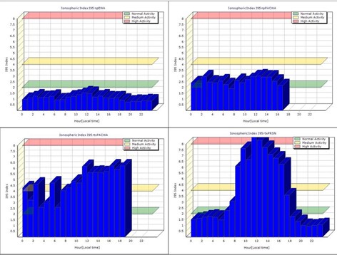
Examples of I95 plots from different subnets on different days. Clockwise from upper left: Below 2 (very low activity), Between 2-4 (normal activity), Between 4-8 (increased activity (noticeable effects), Some periods above 8 (possibly no fixes).
IRIM/GRIM graphs
Another set of plots can help estimate what the positional errors might be due to space weather conditions. Values show the “predicted remaining error” and indicate the estimated impact you could expect in a rover measurement. This is the error that remains that cannot be completely modeled out. IRIM/GRIM can be calculated for the whole network or for individual stations. The network value is the average of the individual stations in a subnet. The method works in a way that, eg, network software takes the whole subnet, takes out one station, and sees how the Iono model fits to the actual observations on that station. The part that does not fit is represented by IRIM. GRIM shows the remaining error with respect to the coordinate. In the example below, during a heightened space weather period, you may have 18mm of IRIM error (left), and 9mm of GRIM error (right) remaining. Of course, the conditions for where you are may vary, but these plots can be a good indicator of expected results.Typically, you will do better than the plots indicate, as they are looking at a whole subnet.
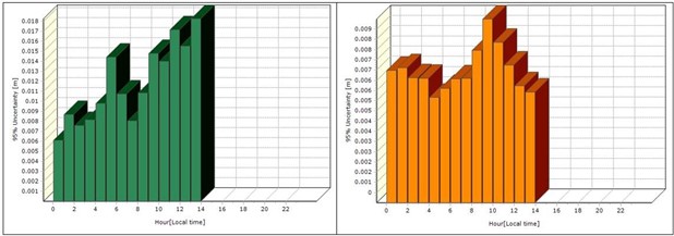
Examples are the IRIM plot (left) and GRIM plot (right).
Note that if you can fix (even under high conditions), you are probably OK, but keep an eye on your residuals. Only when it goes into the red for several hours would you see enough degradation to consider using non-GNSS methods. In our 20+ years of operations, we have only experienced a handful of days when GNSS field operations were not recommended, but often only for a part of those days. If you have a handheld recreational GPS unit and it is having trouble getting a position, that can confirm that the current conditions will not be good for your rover.
-
Is Single Base Better Than VRS?
Choosing Single Base can be better than choosing a Virtual Base Station, but only under very specific conditions.
A Single base solution degrades with distance. If you have a single base (that you can see from the rover or under a km) or a station within a few km, that may yield better results than VRS on days with good ionospheric conditions, but that may vary from day to day. One rule of thumb is to not use single base if you are more than 10km from a station or base. Another is to consider using static methods if possible.
For single base to work its best, the base has to be set up in as good, or better, sky conditions than the rover. That is, with low multipath conditions, and it has to support the same constellations as the rover; and you have to be sure it does not get stolen.
It is possible (but not recommended) to get fixed results from single base at very long baseline lengths, 20km, 30km, and more. The problem is that you will not get consistent results at long baseline lengths as the conditions could vary from day to day, even hour to hour.
Contrary to some marketing-driven rumors from the early days of RTN, VRS does include a physical base station (PBS or PRS); a PBS code is in all VRS corrections. The model of the corrections is virtual, but there is still a tie to a fixed station. Nearly every rover that can export vectors can export the rover-PBS vector.
-
When I Connect To VRS, Sometimes I See Less Satellites, Why Is This?
It can depend on one or more of the following things, the age of your rover, the mountpoint you select or the settings you choose in your survey software. There are new satellite constallations and signals that were only implemented in the past few years. An older rover may not be able to utilize all of the latest sats and signals it “sees”. In legacy VRS/MAC/FKP solutions, it would cull out some satellites that were not fixing, to create the corrections. Your rover would likely not use bypassed sats for the same reason. Some mountpoints support just a subset of the available sats so this could limit the number of sats you are using. Some survey software gives you the option to check a box for each constallation that you want to work with so any box left unchecked would remove those sats from your solution. Also note that your rover needs to use satellites that are in common with 6-9 surrounding CORS stations.
However, in April 2023 we implemented a new feature that includes more satellites for ranging, even if they are not among the fixed ones used in modelling the corrections. While this does not degrade results, it may not necessarily improve results. However, some tests and user feedback have shown it can improve quality and completeness, in certain situations that may have been challenging in the past, with limited satellites. Like in some sky-view challenged locations. In short, you now use more of the sats you see in your solutions (for newer rovers).
-
How Will The Deprecation Of The U.S. Survey Foot Affect C4Gnet.XYZ?
Not at all! Any projection to plane coordinates and feet units is performed in your field and/or office software. There will be no changes to C4Gnet.XYZ related to measurement units. C4Gnet.
Users should consult their respective local jurisdictions and applicable state agencies for any requirements to work in international feet and consult vendors for any questions about how to apply this (if applicable) in their field and/or office software. Read more about the deprecation of the US Survey Foot here.
-
What Are C4Gnet.XYZ Plans For The Upcoming National Datum Shift?
Just like with a base-rover RTK setup or static, there are many factors and sources of error that can affect precision and accuracy: sky view, capabilities of the rover, age and quality of the rover and what constellations it supports, multipath, user errors, space weather conditions, and (to a much lesser degree) weather conditions.
In general, if you are using our survey-grade Network RTK, you should be able to get reliable and repeatable results under 3cm 3D with newer survey-grade gear. If you are using our Mapping/GIS-grade Network Differential (NetDGNSS) with a ‘resource grade’ receiver that is designed to get sub-meter, sub-foot, or decimeter (10cm) results in real-time, these rovers are often used and work well for asset or resource mapping.
-
What Kind Of Results Should I Expect Using C4Gnet.XYZ?
The National Geodetic Survey (NGS) is planning on a new reference framework, NATREF 2022 (but will likely be in 2025 or 2026). This is a significant shift, much like the change from NAD27 to NAD83, by as much as a foot in LA. The state has passed legislation to reflect this change. As we did with the shift from NAD83-CORS96 to NAD83-2011 (in 2012), our RTN will support both the new NATREF datum and the prior NAD83 datum as long as NGS does, and we will provide mountpoints for both, which will allow you to choose NATREF or NAD83 from the NTRIP Caster list of mountpoints.
-
What field procedures should I use to gain confidence in my results?
This is a subject that would take volumes to cover and is much discussed among surveyors and mappers. Using C4Gnet.XYZ or any other RTN is not really different from RTK fundamentals for base-rover. C4G is aware of the steps and analysis that surveyors need to use to have greater confidence in the data they collect using GPS/GNSS—confidence enough to stand behind their data. How each surveyor approaches this process is their call based on their own knowledge and experience. Therefore, we do not weigh in on what the “best” workflow approach would be. Instead, we can relate some of the best practices to help users develop their own workflow to get the best results from using the C4Gnet.XYZ RTN.
Number One Best Practice is to Always Check Your Work
Precision is dependent upon equipment and procedures. Accuracy should be checked relative to a known or assumed standard. C4G constrains its RTN to the currently published NGS NSRS reference frame.
Rovers wanting to check RTN data collected with C4Gnet.XYZ, typically compare RTN RTK (VRS or PPP) positions to static GPS positions in a Post Processing tool like (OPUS) or C4G’s GNSS Online Post Processing service. While this method works well, it takes some time to do these post processed checks. For the highest level of confidence, all accuracy assessments should also include connections to realizations of local coordinate systems and datums.
Network RTK Best Practice Procedures:
- Be In The Box: Users should be aware of the Network Boundaries. Best results will be achieved when you work inside the Network Boundaries.
- Planning: Be aware of satellite geometry as it will have an effect on performance. Well distributed satellites in your sky plot work better than tight groupings of satellites.
- Observing Control: A minimum of one hundred eighty (180) epochs is recommended with a starting rms <30. (Longer observations during summer months may be needed in south Louisiana when water vapor in the atmosphere is higher than normal). For best results, a second set of measurements should be taken no sooner than 45 minutes later. This gap in time is important for the establishment of a different satellite constellation. The measurements need to be made with different satellite geometries. The difference between the two measurements is double the probable error. If it exceeds project requirements, re-observe after a three hour change in satellite geometry. Repeat this method until accuracy meets project requirements. (If repeat measurements are made one after the other you must re-initialize the receiver between measurements.)
- Observing Topo: One five (5) second measurement with an rms <30. If initialization is lost due to high rms, measurements within that initialization should be checked.
- Site Calibration: A site calibration fits the measurements to local control. Errors in the control will change the observed values. In most cases the reported values will provide the best fit to local control.
As with any use of GPS/GNSS, it is a rather mind-blowing proposition that using satellites 20,000km out in space can deliver what is needed to get centimeter results, but there are multiple sources of error that can affect quality and repeatability. When taking a field ‘shot’, an amazing convergence of physics gets applied, and in short, a best practice is to see if it can do that magic repeatedly under the same and slightly different conditions. To do this, multiple observation methods are best practices, doing things like reinitializing, and checking in on test marks, etc. There are tools in the many different field software packages that can help you do this in the field.
Some manufacturers accommodate multiple shots on the same point for a statistical analysis. Some users will reobserve at a different time of day, to affect a different satellite geometry (though there is less of a need for that with so many satellites up there now). There are even options in some field software to have it choose different geometries from the many satellites for you. Some may also offer an option for long observations, say minutes, and it does a kind of convergence, reducing outliers. Your vendor would be the best resource for what approaches might work best with your specific gear.
-
Where Can I Find Control Points To Check Into?
A common method to test your field gear is to check results against published values on passive control marks. While there are caveats to doing this (more on this later), it is a practice that can be quite valuable.
There are many National Geodetic Survey horizontal and vertical control marks, and you can find datasheets for them through their interactive map and text lookup: geodesy.noaa.gov/datasheets/
Several cities and parishes around the state maintain sets of control records.
Keep in mind that when you are comparing an observed position to a published position, you have to make sure you are comparing apples to apples. When using passive control, you need to consider the source, method of establishment, reference framework (datum), and especially the date. For example, there are control marks that may have multiple published values, and none of them are “wrong”. A mark might have an NGS value, a local parish value, etc. They are all valid for the specific folks who published that value. However, you need to consider what date and year the values were established. Due to subsidence and plate tectonics, the value may have changed over 20 years, and there have been successful reference framework (datum) updates.
C4Gnet.XYZ constrains all stations to the National Geodetic Survey National Spatial Reference System (NSRS) to establish active control in Louisiana. When you use C4Gnet.XYZ, you get a position in the NAD83-2011 Epoch 2010.00 reference framework, the same as if you did an NGS OPUS solution. Is the control record expressed in the same reference framework? Likely it has, but look at the date of the record and consider how much movement has happened in the intervening years.
Establishing your own checkpoint can be very useful. Some firms and public entities set a point, for instance, in their parking lot. It comes in handy for seeing if all your gear is working before you head to the field. And to see if all the settings are Ok and you are getting the values on the reference framework you are expecting. There are several common ways folks establish coordinates on their own checkpoints. You could do several days of long static and submit to NGS OPUS. Or do several hours of static and use the WSRN online post-processing tool for several hours. But also keep in mind that (depending on where you are in the state), the plate velocities can change values even after just a year.
-
How Far Outside Of The Network Can I Use It?
While the VRS and PPP corrections will work outside of the network and we have received reports from users of good results up to 70km outside the network, the rule of thumb for base rover RTK should be followed: no more than 10km beyond the outermost stations. Any time your work takes you beyond the outermost stations, extra care should be taken to check positions and validate your results.
-
How Do I Subscribe To C4Gnet.XYZ?
All subscriptions are required to be processed through the C4G Webstore. This website is not directly connected to the RTN Portal, and the accounts are completely separate. If you don’t have an account on the C4G Webstore, start by registering for one here .
Once you have an account, select the product(s) you want to subscribe to and add them to your cart. View your cart to make sure you have the correct product(s), quantity, and price. Any discounts earned or coupons applied should be reflected in the price shown prior to moving to Checkout.
Select Checkout, confirm your address, and select Continue. You will be on Step 3: Payment Method.
- Since the arrival of payment triggers account activation, selecting the Credit Card processed by Authorize.net is the quickest way to activate your subscription.
- Selecting Check / Money Order requires you to remit payment by mail, and your subscription will be activated once the payment arrives at our office.
- To use a PO, get a QUOTE or an INVOICE before ordering; select the Check / Money Order payment option, as it will generate the invoice that you can use for this purpose, and no order is actually placed or activated until the payment is remitted and arrives at our office. Be sure to include the Order # referenced on the invoice generated by the webstore when remitting payment so we can link up the accounts on our end.
Review the C4G REAL-TIME NETWORK SERVICES – TERMS OF SERVICE, check the box to confirm you agree to the TOS, and select Continue.
Credit card transactions are handed off to Authorize.net, which sends payments to LSU’s bank, and once that happens, we are notified by email that the transaction is complete. We then set up your new account or reactivate your current one. Subscription renewals arriving before the expiration of the current one will fall behind the current one and will be rolled over to once the current subscription expires.
If you are purchasing a new account, we will send you the account and login info once it is set up, as this all happens in a different web portal that will have different account credentials from the C4G Webstore.
- Since the arrival of payment triggers account activation, selecting the Credit Card processed by Authorize.net is the quickest way to activate your subscription.
-
Does C4Gnet.XYZ Have An Automated Post-Processing Service?
Yes, we offer the C4Gnet.XYZ GNSS Online Post Processing Service that uses data from all of our CORS (which includes some NGS CORS). This is similar to the NGS OPUS service, which only works (presently) with the GPS constellation, whereas our Online Post Processing Service supports satellites from GPS, GLN, GAL, and BDS constellations.
The C4Gnet.XYZ GNSS Online Post Processing Service provides users with an option to post-process (e.g., when they work out of cell range, or wish to check control values) in an automated service that is constrained to our stations, as well as the NGS CORS, resulting in positions aligned to the National Spatial Reference System (NSRS). Registered users can log in to C4Gnet.XYZ, choose Online Post Processing on the upper left of the page, submit static files, and our system will do the baseline processing. Supported data formats are RINEX 2.xx, RINEX 3.xx, Hatanaka-compressed RINEX files, and Trimble proprietary data formats (DAT, TGD, T01, and T02). Simply upload your static GNSS data, enter your email address and choose to overwrite the rod height or not, and hit the submit button.
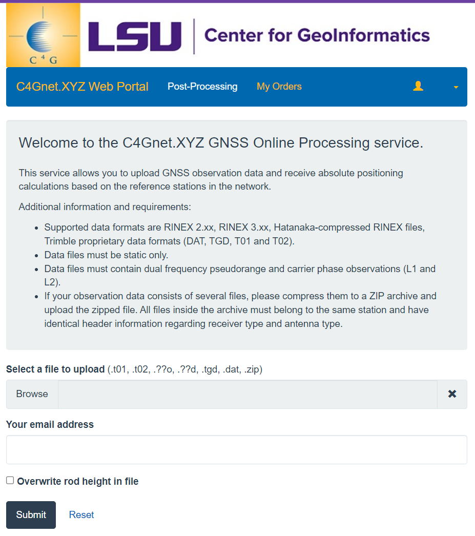
The C4Gnet.XYZ GNSS Online Post Processing Service will email a PDF of the results once it finishes processing, or you can download a copy of the report in PDF and/or an XML file format directly from the C4Gnet.XYZ web portal. The results are in NAD83-2011 coordinates (not state plane; you will need to convert that yourself) and include both ellipsoidal and orthometric heights. C4G provides free subscriptions to this service to anyone who contacts us and requests access. Using this tool can be a good supplement to validate or check control values on various field operations.
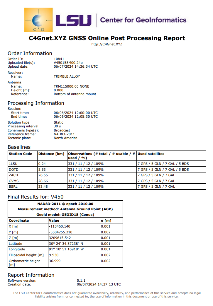
Example Report:
-
Can I Use C4Gnet.XYZ For My Drone Operations?
Certainly, but there can be a lot of nuance to this answer, as there are many different approaches that drone (UAS) operators take to meet their desired relative/absolute precision and accuracy goals. You can use the C4Gnet.XYZ services, real-time or static, as part of such varied approaches – when appropriate.
For many drone operations, setting up a base on the site can be the best choice. Be that for real-time (RTK), or post-processing (baseline and PPK). This is because a very short baseline length can yield the best results. However, if your site is only a short distance from a C4Gnet.XYZ station (e.g., under 10km on a good iono day), this could work well for RTK and/or static post-processing. Some users use VRS for their real-time data, and/or for establishing ground control points (GCP). Some users will use Virtual Rinex, generated for virtual locations in their project area.
Generally, working without GCP is not a preferred choice, unless you are only interested in relative precision, and even for that, including at least some GCP can be a best practice.
One aspect of processing drone data is the inertial (IMU) data, that when processed together with the observations from the on-board GNSS, in a PPK workflow, has grown in popularity. It is not as if PPK is much different than RTK (it is simply delayed RTK so to speak) but the addition of the IMU, and precise orbit data, that can make a difference. Your drone vendor can recommend software to do this PPK/IMU step. This is essentially the same as many mobile mapping workflows.