2010 South Louisiana GNSS Network Results Webinar
Note that the LSU Center for GeoInformatics is actively pursuing the funding necessary to do the control work needed to create better GEOID models in Louisiana. Feeding well distributed vertical control data into future GEOID models will improve the vertical accuracy of these models and is perhaps our only hope of ever creating a ±1cm GEOID in the state of Louisiana. |
||
|---|---|---|
|
The NGS presentation on Friday March 15, 2013, pointed out that GEOID12a produces 95% confidence at ± 4 to 8 cm in Louisiana. The NGS conclusion states that the problem is too large for NGS to handle alone and we all need to work together to get better height results. They also recommend partnering with locals to leverage existing resources and that a plan needed to be created to move forward with improving heights. |
|
|
|
The presentation was given by NGS geodesists / scientists, Michael Dennis and Dan Roman.
|
||
|
Big picture ideas to consider from the presentation
|
||
|
Recently, NOAA’s National Geodetic Survey released updated orthometric heights for Southern Louisiana relative to the September 2010 GNSS Height Modernization project. These heights represent the most up to date heights available for the region. On March 15, 2013, NGS hosted a free, on-line webinar to present the results of this project. |
|
Visit the NGS page for this event To download the .mp4 file, click here. Link to the presentation: |
C4G Web Map Tool for GPS on BenchMarks
Benjamin Fernandez has built this tool optimized for Louisiana that you can use by simply putting in a place, address or zipcode to search for what Benchmarks are needed in any area your interested in.
La. R.S. 50:173.1. Vertical control standards
Vertical controls for all surveys shall be determined in the North American Vertical Datum of 1988 (NAVD88). All measurements shall be referenced to local control stations of the National Spatial Reference System, specifically the public domain Louisiana State University Continuously Operating Reference Stations network or other currently National Oceanographic and Atmospheric Administration National Geodetic Survey approved reference stations, such as benchmarks, monuments, or continually operating reference stations.
Free Post-Processing Services
C4Gnet.XYZ GNSS Online Post Processing - powered by Trimble Online Processing App
Works throughout Louisiana and some parts of Mississippi and Texas.
Get a Free C4Gnet.XYZ GNSS Online Post Processing Service Account, user accounts are available for the C4Gnet.XYZ GNSS Online Post Processing Service which requires a yearly free subscription that is available simply by asking one of the C4Gnet.XYZ administrators. To get a free user account, first Register Here then send an email to
Here is a list of other free online GPS post-processing services:
- OPUS: (Currently Under Government Shutdown) NGS GPS Data Processing Online Positioning User Service
- CSRS-PPP: Canadian Spatial Reference System, Natural Resources Canada
- AUSPOS: Geoscience Australia
- GAPS: University of New Brunswick
- APPS: Jet Propulsion Laboratory
- SCOUT: Scripps Orbit and Permanent Array Center (SOPAC). University of California, San Diego
- magicGNSS: GMV
- CenterPoint RTX: Trimble Navigation
Page 2 of 2

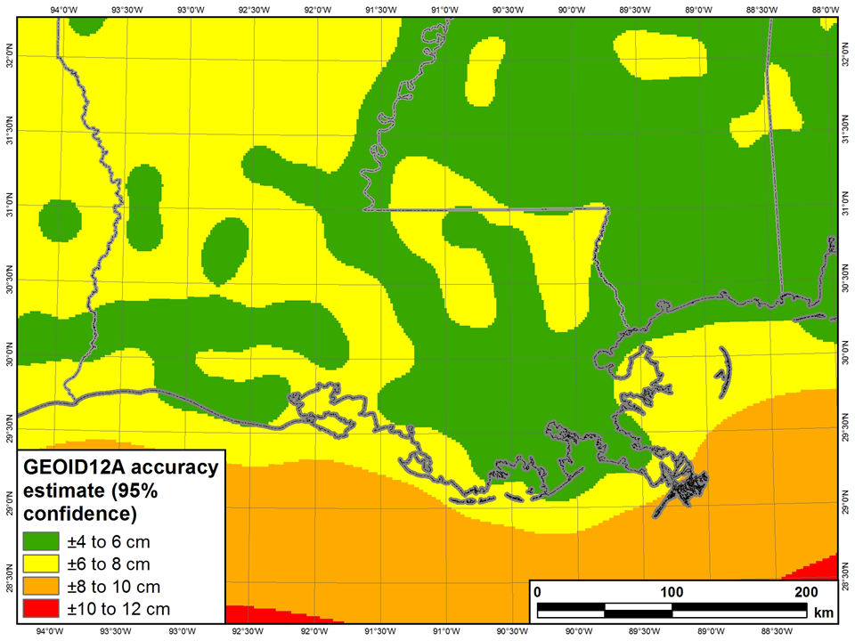 NGS plot shows GEOID12a produces 95% confidence at ± 4 to 8 cm in Louisiana