
GPS only provides ellipsoid height – very accurate and very precise, but that is not elevation. To obtain elevation information from an ellipsoid height we must utilize a theoretical model of the earth’s gravity field called “the geoid.” Our knowledge of the geoid is only approximate, and it is very faulty in Louisiana because of the constant surface and subterranean movement due to consolidation, faulting, salt domes, and subsidence – the result being largely responsible for “coastal erosion” and the inability of benchmarks to remain reliable for more than a couple of years or so. Therefore, the primary thrust of research must be with regard to a better understanding of the geoid as it exists in Louisiana coupled with the systematic processing of the decade of GPS observations archived in LSU’s server banks. 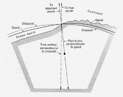 We have a research plan that is in physical geodesy which involves GPS observations, coupled with absolute gravity field observations at the same locations, and with zenith camera observations to determine the slope of the geoid at those same locations. Eventually, many of those locations will need to be observed in precise geodetic leveling campaigns (a very expensive proposition also).
In the 1980s, benchmark densification projects were undertaken in Orleans, Jefferson, St. Bernard, and Plaquemines Parishes. These projects consisted of 1st- and 2nd-Order Geodetic Leveling observations accompanied by 2nd-Order Relative Gravity (double ladder) observation surveys. The total number of benchmarks surveyed was over 500 monuments, and all observations and descriptions were Blue Booked, accepted, and published by the National Geodetic Survey. This was later followed by FG-5 Absolute Gravity observations first at the University of New Orleans which was observed multiple times and then at numerous GPS Continuously Operating Reference Station (CORS) sites throughout the State of Louisiana, some more than once by either the National Geodetic Survey or the National Geospatial-Intelligence Agency. The density of these observations were at approx. 100 mile distances, and are not sufficient to provide significant data points to improve the geoid model. The primary purpose for these observations was to provide an independent check on changes in ellipsoid heights observed at the LSU CORS sites.
Equipment needed is an A-10 Absolute Gravity Meter and a CODIAC Zenith Camera to supplement GPS observations in South Louisiana (and eventually North Louisiana). The National Geodetic Survey recommends an observational density grid of 40 kilometers which will occupy field researchers for many years. That data combined with our existing database will insure that the LSU GPS Real Time Network will provide centimeter-level accuracy for elevations throughout the state; a prime example of the direct impact that research has on practical applications.