
C4G launched C4Gnet.XYZ in January 2018 and this launch had so many important advancements bundled into it that there is too much to give all the details in the RTN User Guide. In this article we will try to give you some insight on the tools and features that are all rolled up into the C4Gnet.XYZ RTN launch.
First a little background information on the very important change to C4Gnet.XYZ.
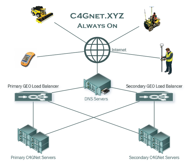
C4G originally made the switch to using RTN as our host address years ago to provide a robust failover method that allows RTN users to be directed to any of our servers without having to make any changes in their rover settings. We have a network of high availability firewalls, load balancers and database servers that are monitored for quality of services and weighting and direct clients accordingly to the best services dynamically. This made the C4Gnet RTN very reliable and is only possible when clients use DNS for the host address. This DNS or Domain Name System was based on the top level DNS of LSU.EDU and worked perfect for years until LSU made a change to tools that manage DNS for the LSU.EDU top level domain. This change required the DNS to be pointed to a single IP address removing the ability for C4G to redirect the DNS dynamically! The only way to fix this was to get a new DNS that was not connected to the top level DNS, LSU.EDU, so C4G acquired the domain C4Gnet.XYZ in an effort to restore our robust dynamic failover capability.
- C4Gnet.XYZ restores our High Availability Always On robust failover ability and we encourage all clients that can use DNS Host Addresses in their rover setups to do so!
With this launch the LSU Center for GeoInformatics introduces a new version of the Trimble Pivot Platform software package.
New features deployed in this software release include the following:
- C4Gnet GNSS Online Post Processing
- VRS iScope
- iScope Live!
- Real Time RTXnet Processor using Precise Point Positioning (PPP)
- New mountpoint naming convention
- New PPP and NSB Mountpoints
- Multi-Reference Frame Support
- GNSS Galileo and BeiDou Support
RTX Technology
The RTX Technology infrastructure is a unified framework for estimating satellite parameters for any GNSS satellite. GNSS field receivers use advanced Precise Point Positioning (PPP) processing algorithms to combine RTX corrections with local measurements and produce cm level accurate absolute positions.
RTXNet Processor
RTX Technology enables the RTXNet Processor to develop corrections for a full range of satellite systems and delivers Network-RTK corrections for GPS, GLONASS, BeiDou, Galileo, and QZSS. Using a PPP mountpoint gives rovers a second real-time method to collect data and as a real-time way to check data collected with a real-time VRS RTK mountpoint. If data collected with both PPP and RTK agree, you have a very high confidence that the data collected is accurate.